
Сделать пожертвование
Топографическая карта Harford County
Нажмите на карту, чтобы отобразить высоту.
Сделать пожертвование
Harford County
Harford County straddles the border between the rolling hills of the Piedmont Plateau and the flatlands of the Atlantic Coastal Plain along the Chesapeake Bay and its tributaries. The county's development is a mix of rural and suburban, with denser development in the larger towns of Aberdeen and Bel Air and along Route 40 and other major arteries leading out of Baltimore. The highest elevations are in the north and northwest of the county, reaching 805 ft. near the Pennsylvania border in the county's northwestern corner. The lowest elevation is sea level along the Chesapeake Bay.
Сделать пожертвование
Об этой карте
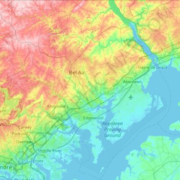
Название: Топографическая карта Harford County, высота, рельеф.
Местонахождение: Harford County, Maryland, United States (39.25801 -76.56945 39.72129 -76.03564)
Средняя высота: 70 м
Минимальная высота: -3 м
Максимальная высота: 237 м
Сделать пожертвование
Другие топографические карты
Нажмите на карту, чтобы просмотреть ее топографию, ее высоту и ее рельеф.
Baltimore
United States > Maryland > Baltimore
Baltimore is in north-central Maryland on the Patapsco River close to where it empties into the Chesapeake Bay. The city is also located on the fall line between the Piedmont Plateau and the Atlantic coastal plain, which divides Baltimore into "lower city" and "upper city". The city's elevation ranges from sea…
Средняя высота: 65 м
Сделать пожертвование
Сделать пожертвование
Сделать пожертвование
Сделать пожертвование
Highland
United States > Maryland > Frederick County
The majority of the downtown Highland district is situated within the 418-acre (169 ha) land grant named "Hickory Ridge". The Rouse Company borrowed the land grant name for one of its nearby villages of Columbia, built in 1974. The historic "White Hall" or "Hickory Ridge" estate (1749) was owned by the…
Средняя высота: 357 м
Сделать пожертвование
Сделать пожертвование
Hoye-Crest
United States > Maryland > Garrett County
Hoye-Crest is a summit along Backbone Mountain just inside of Garrett County, Maryland. It is the highest natural point in Maryland at an elevation of 3,360 feet (1,020 m).
Средняя высота: 887 м
Сделать пожертвование
Quiet Waters Park
United States > Maryland > Anne Arundel County > Annapolis > Georgetown East
Средняя высота: 7 м
Сделать пожертвование
Сделать пожертвование
Catoctin Mountain
United States > Maryland > Frederick County
Catoctin Mountain traverses Frederick County, Maryland and extends into northern Loudoun County, Virginia. It rises to its greatest elevation of 1,900 feet (580 m) above sea level just southwest of Cunningham Falls State Park and is transected by gaps at Braddock Heights (Fairview Pass), Point of Rocks on the…
Средняя высота: 471 м
Сделать пожертвование
Сделать пожертвование
Сделать пожертвование
Сделать пожертвование
Antietam National Battlefield
United States > Maryland > Washington County > Sharpsburg
Средняя высота: 147 м
Сделать пожертвование
Сделать пожертвование
Damascus
United States > Maryland > Montgomery County
As an unincorporated area, Damascus' boundaries are not officially defined. Damascus is recognized by the United States Census Bureau as a census-designated place, and by the United States Geological Survey as a populated place located at 39°16′16″N 77°12′22″W / 39.27111°N 77.20611°W /…
Средняя высота: 204 м
Сделать пожертвование
Сделать пожертвование
Сделать пожертвование
Сделать пожертвование
Сделать пожертвование
Сделать пожертвование
Сделать пожертвование
Сделать пожертвование
Сделать пожертвование
Сделать пожертвование