
Сделать пожертвование
Топографическая карта Hoye-Crest
Нажмите на карту, чтобы отобразить высоту.
Сделать пожертвование
Hoye-Crest
Hoye-Crest is a summit along Backbone Mountain just inside of Garrett County, Maryland. It is the highest natural point in Maryland at an elevation of 3,360 feet (1,020 m).
Сделать пожертвование
Об этой карте
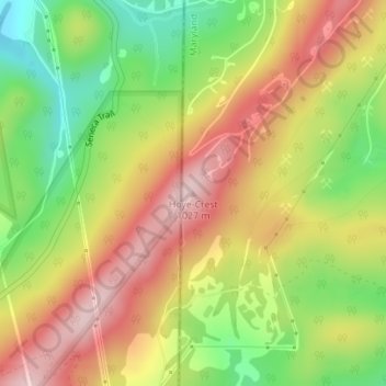
Название: Топографическая карта Hoye-Crest, высота, рельеф.
Местонахождение: Hoye-Crest, Garrett County, Maryland, 26716, United States (39.23748 -79.48542 39.23758 -79.48532)
Средняя высота: 887 м
Минимальная высота: 743 м
Максимальная высота: 1 022 м
Сделать пожертвование
Другие топографические карты
Нажмите на карту, чтобы просмотреть ее топографию, ее высоту и ее рельеф.
Oakland
United States > Maryland > Garrett County
Oakland, owing to its high elevation and valley location, is among the coldest and snowiest locales in the state of Maryland, and has a warm-summer humid continental climate (Köppen Dfb). The state record low of −40 °F or −40 °C was recorded here on January 13, 1912. The monthly mean temperature ranges…
Средняя высота: 763 м
Сделать пожертвование
Savage River State Forest
United States > Maryland > Garrett County > Grantsville
Средняя высота: 738 м