
Сделать пожертвование
Топографическая карта Damascus
Нажмите на карту, чтобы отобразить высоту.
Сделать пожертвование
Damascus
As an unincorporated area, Damascus' boundaries are not officially defined. Damascus is recognized by the United States Census Bureau as a census-designated place, and by the United States Geological Survey as a populated place located at 39°16′16″N 77°12′22″W / 39.27111°N 77.20611°W / 39.27111; -77.20611 (39.271040, −77.206098). Damascus proper is a locally high spot at 847 ft (258m) above sea level, while other portions of the area described as Damascus are as high as 866 ft (264m) above sea level. However the highest elevation in the county is actually within what is considered Mt. Airy, MD, measuring 883 ft (269m) above sea level at the Full Gospel Church. This peak just southwest of Mt. Airy is actually the highest elevation in the immediately adjacent Washington D.C. suburbs.
Сделать пожертвование
Об этой карте
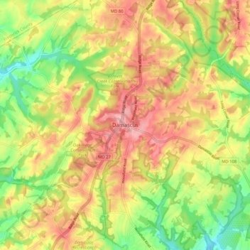
Название: Топографическая карта Damascus, высота, рельеф.
Местонахождение: Damascus, Montgomery County, Maryland, 20872, United States (39.24844 -77.24387 39.32844 -77.16387)
Средняя высота: 204 м
Минимальная высота: 140 м
Максимальная высота: 260 м
Сделать пожертвование
Другие топографические карты
Нажмите на карту, чтобы просмотреть ее топографию, ее высоту и ее рельеф.
Сделать пожертвование
Сделать пожертвование
Cabin John
United States > Maryland > Montgomery County > Cabin John
Historically, Cabin John has been part of the region known as the Potomac Gorge (Potomac Palisades), an approximately 15-mile-long (24 km) corridor or "fall zone" that sees a transition between the hard bedrock of the Piedmont to the softer rocks and soils of the Atlantic Coastal Plain and representing a drop…
Средняя высота: 48 м
Сделать пожертвование
Damascus
United States > Maryland > Montgomery County > Damascus
As an unincorporated area, Damascus' boundaries are not officially defined. Damascus is recognized by the United States Census Bureau as a census-designated place, and by the United States Geological Survey as a populated place located at 39°16′16″N 77°12′22″W / 39.27111°N 77.20611°W /…
Средняя высота: 195 м
Сделать пожертвование
North Potomac
United States > Maryland > Montgomery County > North Potomac
Between the 1990 and 2000 census, North Potomac gained and lost land. The loss was caused when a portion of the North Potomac territory, plus Potomac territory, was used to create the Travilah census designated place. According to the United States Census Bureau, North Potomac has a total area of 6.6 square…
Средняя высота: 116 м
Burnt Mills West Special Park
United States > Maryland > Montgomery County > Burnt Mills > Burnt Mills Manor
Средняя высота: 100 м
Сделать пожертвование
Damascus
United States > Maryland > Montgomery County > Damascus
As an unincorporated area, Damascus' boundaries are not officially defined. Damascus is recognized by the United States Census Bureau as a census-designated place, and by the United States Geological Survey as a populated place located. Damascus proper is a locally high spot at 847 ft (258m) above sea level,…
Средняя высота: 195 м
Сделать пожертвование
Сделать пожертвование
Forest Glen
United States > Maryland > Montgomery County > Forest Glen > McKenney Hills
Средняя высота: 105 м
Сделать пожертвование
Upper Long Branch Neighborhood Park
United States > Maryland > Montgomery County > Four Corners
Средняя высота: 87 м
Сделать пожертвование
Сделать пожертвование
Damascus
United States > Maryland > Montgomery County > Damascus
As an unincorporated area, Damascus' boundaries are not officially defined. Damascus is recognized by the United States Census Bureau as a census-designated place, and by the United States Geological Survey as a populated place located. Damascus proper is a locally high spot at 847 ft (258m) above sea level,…
Средняя высота: 195 м
Сделать пожертвование
Colt Terrace Neighborhood Park
United States > Maryland > Montgomery County > Silver Spring
Средняя высота: 119 м
Сделать пожертвование
Forest Glen
United States > Maryland > Montgomery County > Forest Glen > McKenney Hills
Средняя высота: 105 м
Сделать пожертвование
Travilah
United States > Maryland > Montgomery County > Travilah
The United States Geological Survey lists six features in Montgomery County with Travilah in all or part of their name. The Travilah Census Designated Place has an ID of 2390400 and an elevation of 233 feet. It has a latitude of 390325N and a longitude of 0771445W—a location of 39°3′25″N…
Средняя высота: 96 м
Сделать пожертвование
North Kensington
United States > Maryland > Montgomery County > North Kensington
Средняя высота: 103 м
Сделать пожертвование
Forest Glen
United States > Maryland > Montgomery County > Forest Glen > Forest Estates
Средняя высота: 105 м
Сделать пожертвование