
Сделать пожертвование
Топографическая карта McHenry
Нажмите на карту, чтобы отобразить высоту.
Сделать пожертвование
Об этой карте
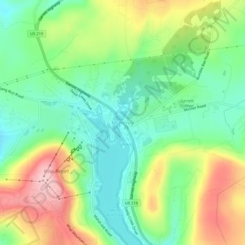
Название: Топографическая карта McHenry, высота, рельеф.
Местонахождение: McHenry, Garrett County, Maryland, 21541, United States (39.53842 -79.37282 39.57842 -79.33282)
Средняя высота: 817 м
Минимальная высота: 738 м
Максимальная высота: 943 м
Сделать пожертвование
Другие топографические карты
Нажмите на карту, чтобы просмотреть ее топографию, ее высоту и ее рельеф.
Oakland
United States > Maryland > Garrett County
Oakland, owing to its high elevation and valley location, is among the coldest and snowiest locales in the state of Maryland, and has a warm-summer humid continental climate (Köppen Dfb). The state record low of −40 °F or −40 °C was recorded here on January 13, 1912. The monthly mean temperature ranges…
Средняя высота: 763 м
Сделать пожертвование
Savage River State Forest
United States > Maryland > Garrett County > Grantsville
Средняя высота: 738 м