
Сделать пожертвование
Топографическая карта Montgomery County
Нажмите на карту, чтобы отобразить высоту.
Сделать пожертвование
Montgomery County
According to the U.S. Census Bureau, the county has a total area of 507 square miles (1,310 km2), of which 491 square miles (1,270 km2) is land and 16 square miles (41 km2) (3.1%) is water. Montgomery County lies entirely inside the Piedmont plateau. The topography is generally rolling. Elevations range from a low of near sea level along the Potomac River to about 875 feet in the northernmost portion of the county north of Damascus. Relief between valley bottoms and hilltops is several hundred feet. Earthquakes are rare; the most recent one, on June 24, 2024, had a 1.8 magnitude and was centered near Spencerville, Maryland.
Сделать пожертвование
Об этой карте
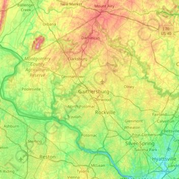
Название: Топографическая карта Montgomery County, высота, рельеф.
Местонахождение: Montgomery County, Maryland, United States (38.93435 -77.52738 39.35432 -76.88766)
Средняя высота: 120 м
Минимальная высота: -2 м
Максимальная высота: 368 м
Сделать пожертвование
Другие топографические карты
Нажмите на карту, чтобы просмотреть ее топографию, ее высоту и ее рельеф.
Baltimore
United States > Maryland > Baltimore
Baltimore is in north-central Maryland on the Patapsco River close to where it empties into the Chesapeake Bay. The city is also located on the fall line between the Piedmont Plateau and the Atlantic coastal plain, which divides Baltimore into "lower city" and "upper city". The city's elevation ranges from sea…
Средняя высота: 65 м
Сделать пожертвование
Сделать пожертвование
Сделать пожертвование
Highland
United States > Maryland > Frederick County
The majority of the downtown Highland district is situated within the 418-acre (169 ha) land grant named "Hickory Ridge". The Rouse Company borrowed the land grant name for one of its nearby villages of Columbia, built in 1974. The historic "White Hall" or "Hickory Ridge" estate (1749) was owned by the…
Средняя высота: 357 м
Сделать пожертвование
Сделать пожертвование
Hoye-Crest
United States > Maryland > Garrett County
Hoye-Crest is a summit along Backbone Mountain just inside of Garrett County, Maryland. It is the highest natural point in Maryland at an elevation of 3,360 feet (1,020 m).
Средняя высота: 887 м
Сделать пожертвование
Quiet Waters Park
United States > Maryland > Anne Arundel County > Annapolis > Georgetown East
Средняя высота: 7 м
Сделать пожертвование
Сделать пожертвование
Сделать пожертвование
Сделать пожертвование
Сделать пожертвование
Сделать пожертвование
Antietam National Battlefield
United States > Maryland > Washington County > Sharpsburg
Средняя высота: 147 м
Сделать пожертвование
Сделать пожертвование
Damascus
United States > Maryland > Montgomery County
As an unincorporated area, Damascus' boundaries are not officially defined. Damascus is recognized by the United States Census Bureau as a census-designated place, and by the United States Geological Survey as a populated place located at 39°16′16″N 77°12′22″W / 39.27111°N 77.20611°W /…
Средняя высота: 204 м
Сделать пожертвование
Сделать пожертвование
Сделать пожертвование
Сделать пожертвование
Сделать пожертвование
Сделать пожертвование
Сделать пожертвование
Сделать пожертвование
Сделать пожертвование
Сделать пожертвование
Сделать пожертвование