
Сделать пожертвование
Топографическая карта Monticello
Нажмите на карту, чтобы отобразить высоту.
Сделать пожертвование
Monticello
Monticello is located at the base of the Abajo Mountains, or the Blue Mountains, which are part of the Manti-La Sal National Forest. The elevation of Monticello is 7,069 feet (2,155 m). From Monticello, a tree formation on the Blue Mountains can be seen, which resembles a horse's head and neck, which can be seen from any point in town.
Сделать пожертвование
Об этой карте
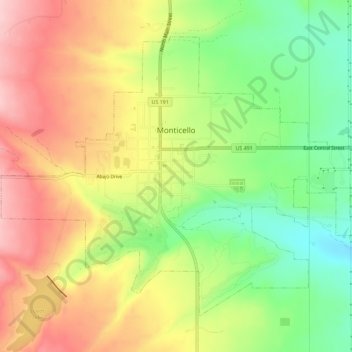
Название: Топографическая карта Monticello, высота, рельеф.
Местонахождение: Monticello, San Juan County, Utah, United States (37.85117 -109.36881 37.88708 -109.31155)
Средняя высота: 2 145 м
Минимальная высота: 2 049 м
Максимальная высота: 2 240 м
Сделать пожертвование
Другие топографические карты
Нажмите на карту, чтобы просмотреть ее топографию, ее высоту и ее рельеф.
Сделать пожертвование
Colorado Plateau
United States > Utah > San Juan County
Younger igneous rocks form spectacular topographic features. The Henry Mountains, La Sal Range, and Abajo Mountains, ranges that dominate many views in southeastern Utah, are formed about igneous rocks that were intruded in the interval from 20 to 31 million years: some igneous intrusions in these mountains…
Средняя высота: 1 512 м
Сделать пожертвование
Colorado Plateau
United States > Utah > San Juan County
Younger igneous rocks form spectacular topographic features. The Henry Mountains, La Sal Range, and Abajo Mountains, ranges that dominate many views in southeastern Utah, are formed about igneous rocks that were intruded in the interval from 20 to 31 million years: some igneous intrusions in these mountains…
Средняя высота: 1 512 м