
Сделать пожертвование
Топографическая карта Upheaval Dome
Нажмите на карту, чтобы отобразить высоту.
Сделать пожертвование
Об этой карте
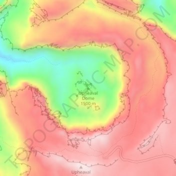
Название: Топографическая карта Upheaval Dome, высота, рельеф.
Местонахождение: Upheaval Dome, San Juan County, Utah, United States (38.43691 -109.92905 38.43701 -109.92895)
Средняя высота: 1 627 м
Минимальная высота: 1 331 м
Максимальная высота: 1 802 м
Сделать пожертвование
Другие топографические карты
Нажмите на карту, чтобы просмотреть ее топографию, ее высоту и ее рельеф.
Сделать пожертвование
Natural Bridges National Monument
United States > Utah > San Juan County
Located within the Colorado Plateau, the monument has three distinct bridges in White and Armstrong Canyons. These canyons were formed when the Colorado River eroded the Permian Cedar Mesa Sandstone. The Sipapu, Kachina, and Owachoma bridges were formed through rock decay, weathering and erosion, as water cut…
Средняя высота: 1 916 м
Сделать пожертвование
Сделать пожертвование
Сделать пожертвование
Monticello
United States > Utah > San Juan County
Monticello is located at the base of the Abajo Mountains, or the Blue Mountains, which are part of the Manti-La Sal National Forest. The elevation of Monticello is 7,069 feet (2,155 m). From Monticello, a tree formation on the Blue Mountains can be seen, which resembles a horse's head and neck, which can be…
Средняя высота: 2 145 м
Сделать пожертвование