
Сделать пожертвование
Топографическая карта Upper Sichey
Нажмите на карту, чтобы отобразить высоту.
Сделать пожертвование
Об этой карте
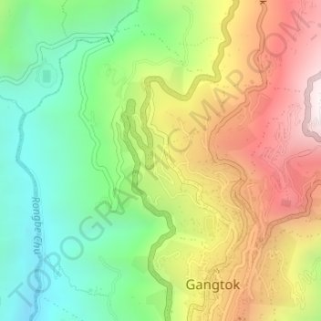
Название: Топографическая карта Upper Sichey, высота, рельеф.
Местонахождение: Upper Sichey, Gangtok, East Sikkim District, Sikkim, India (27.33253 88.60389 27.34635 88.61388)
Средняя высота: 1 459 м
Минимальная высота: 1 005 м
Максимальная высота: 2 045 м
Сделать пожертвование
Другие топографические карты
Нажмите на карту, чтобы просмотреть ее топографию, ее высоту и ее рельеф.
Сделать пожертвование
Gangtok
India > Sikkim > Gangtok subdivision
Gangtok (Nepali: [gantok] gāntok, Sikkimese: [ɡaŋt̪ʰòk]) is the capital and the most populous city of the Indian state of Sikkim. The seat of eponymous district, Gangtok is in the eastern Himalayan range, at an elevation of 1,650 m (5,410 ft). The city's population of 100,000 consists of the three…
Средняя высота: 1 911 м
Сделать пожертвование
Kangchenjunga
India > Sikkim > Chungthang
Kangchenjunga Main is the highest elevation of the Brahmaputra River basin, which forms part of the southeast Asian monsoon regime and is among the globally largest river basins. Kangchenjunga is one of six peaks above 8,000 m (26,000 ft) located in the basin of the Kosi River, which is among the largest…
Средняя высота: 7 725 м
Сделать пожертвование
Gangtok
India > Sikkim > Gangtok subdivision
Gangtok (Nepali: gāntok, pronounced [gantok], Sikkimese: [ɡaŋt̪ʰòk]) is the capital and the most populous city of the Indian state of Sikkim. The seat of eponymous district, Gangtok is in the eastern Himalayan range, at an elevation of 1,650 m (5,410 ft). The city's population of 100,000 consists of the…
Средняя высота: 1 911 м
Сделать пожертвование
Ravangla
Rabong or Ravangla is a small town with an elevation of 8000 feet located, near Namchi City in the Namchi district of the Indian state of Sikkim. It is connected by state highway to other major towns in the state and lies between Namchi, Pelling and Gangtok. It is the starting point for the trek to Maenam…
Средняя высота: 1 870 м
Kangchenjunga
India > Sikkim > Chungthang
Kangchenjunga Main is the highest elevation of the Brahmaputra River basin, which forms part of the southeast Asian monsoon regime and is among the globally largest river basins. Kangchenjunga is one of six peaks above 8,000 m (26,000 ft) located in the basin of the Kosi River, which is among the largest…
Средняя высота: 7 725 м
Сделать пожертвование
Ravangla
Rabong or Ravangla is a small town with an elevation of 8000 feet located, near Namchi City in the Namchi district of the Indian state of Sikkim. It is connected by state highway to other major towns in the state and lies between Namchi, Pelling and Gangtok. It is the starting point for the trek to Maenam…
Средняя высота: 1 870 м
Сделать пожертвование
Сделать пожертвование
Singtam
Singtam is located at 27°09′N 88°23′E / 27.15°N 88.38°E / 27.15; 88.38. It has an average elevation of 1396 feet. As the town lies on the bank of two rivers River Teesta and Ranikhola, so during Monsoon especially from June to September the volume of both the river increases heavily, as a…
Средняя высота: 894 м
Сделать пожертвование
Kangchenjunga
India > Sikkim > Chungthang
Kangchenjunga Main is the highest elevation of the Brahmaputra River basin, which forms part of the southeast Asian monsoon regime and is among the globally largest river basins. Kangchenjunga is one of six peaks above 8,000 m (26,000 ft) located in the basin of the Kosi River, which is among the largest…
Средняя высота: 7 725 м
Сделать пожертвование
Lachung
India > Sikkim > Chungthang
Lachung is a town and hill station in northeast Sikkim, India. It is located in the North Sikkim district near the border with Tibet. Lachung is at an elevation of about 9,600 feet (2,900 m) and at the confluence of the Lachen and Lachung Rivers, both tributaries of the River Teesta. The word Lachung means…
Средняя высота: 3 617 м