
Топографическая карта Leeds
Интерактивная карта
Нажмите на карту, чтобы отобразить высоту.
Об этой карте
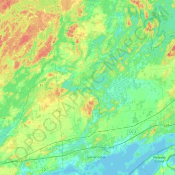
Название: Топографическая карта Leeds, высота, рельеф.
Местонахождение: Leeds, Leeds and the Thousand Islands, Leeds and Grenville Counties, Eastern Ontario, Ontario, Canada (44.30171 -76.25483 44.56976 -76.10427)
Средняя высота: 104 м
Минимальная высота: 73 м
Максимальная высота: 185 м
Другие топографические карты
Нажмите на карту, чтобы просмотреть ее топографию, ее высоту и ее рельеф.
Why Island
Canada > Ontario > Leeds and Grenville Counties > Leeds and the Thousand Islands
Средняя высота: 92 м
Outlet
Canada > Ontario > Leeds and Grenville Counties > Leeds and the Thousand Islands
Средняя высота: 97 м
Seeleys Bay
Canada > Ontario > Leeds and Grenville Counties > Leeds and the Thousand Islands > Seeley's Bay
Средняя высота: 105 м
Lansdowne
Canada > Ontario > Leeds and Grenville Counties > Leeds and the Thousand Islands
Средняя высота: 101 м
Seeleys Bay
Canada > Ontario > Leeds and Grenville Counties > Leeds and the Thousand Islands > Seeley's Bay
Средняя высота: 105 м
Lyndhurst
Canada > Ontario > Leeds and Grenville Counties > Leeds and the Thousand Islands
Средняя высота: 98 м
Waterton
Canada > Ontario > Leeds and Grenville Counties > Leeds and the Thousand Islands > Waterton
Средняя высота: 97 м
Seeley's Bay
Canada > Ontario > Leeds and Grenville Counties > Leeds and the Thousand Islands
Средняя высота: 106 м