
Топографическая карта Lyndhurst
Интерактивная карта
Нажмите на карту, чтобы отобразить высоту.
Об этой карте
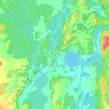
Название: Топографическая карта Lyndhurst, высота, рельеф.
Средняя высота: 98 м
Минимальная высота: 81 м
Максимальная высота: 130 м
Другие топографические карты
Нажмите на карту, чтобы просмотреть ее топографию, ее высоту и ее рельеф.
Lansdowne
Canada > Ontario > Leeds and Grenville Counties > Leeds and the Thousand Islands
Lansdowne, Leeds and the Thousand Islands, Leeds and Grenville Counties, Eastern Ontario, Ontario, K0E 1L0, Canada
Средняя высота: 101 м
Seeleys Bay
Canada > Ontario > Leeds and Grenville Counties > Leeds and the Thousand Islands > Seeley's Bay
Seeleys Bay, Seeley's Bay, Leeds and the Thousand Islands, Leeds and Grenville Counties, Eastern Ontario, Ontario, K0H 2N0, Canada
Средняя высота: 105 м
Leeds
Canada > Ontario > Leeds and Grenville Counties > Leeds and the Thousand Islands
Leeds, Leeds and the Thousand Islands, Leeds and Grenville Counties, Eastern Ontario, Ontario, Canada
Средняя высота: 104 м
Seeley's Bay
Canada > Ontario > Leeds and Grenville Counties > Leeds and the Thousand Islands > Seeley's Bay
Seeley's Bay, Leeds and the Thousand Islands, Leeds and Grenville Counties, Eastern Ontario, Ontario, K0H 2N0, Canada
Средняя высота: 106 м
Blue Mountain
Canada > Ontario > Leeds and Grenville Counties > Leeds and the Thousand Islands
Blue Mountain, Leeds and the Thousand Islands, Leeds and Grenville Counties, Eastern Ontario, Ontario, Canada
Средняя высота: 124 м
Waterton
Canada > Ontario > Leeds and Grenville Counties > Leeds and the Thousand Islands > Waterton
Waterton, Leeds and the Thousand Islands, Leeds and Grenville Counties, Eastern Ontario, Ontario, Canada
Средняя высота: 97 м