
Сделать пожертвование
Топографическая карта Banff National Park
Нажмите на карту, чтобы отобразить высоту.
Сделать пожертвование
Banff National Park
Banff National Park has a subarctic climate with three ecoregions, including montane, subalpine, and alpine. The forests are dominated by Lodgepole pine at lower elevations and Engelmann spruce in higher ones below the treeline, above which is primarily rocks and ice. Mammal species such as the grizzly bear, cougar, wolverine, elk, bighorn sheep and moose are found, along with hundreds of bird species. Reptiles and amphibians are also found but only a limited number of species have been recorded. The mountains are formed from sedimentary rocks which were pushed east over newer rock strata, between 80 and 55 million years ago. Over the past few million years, glaciers have at times covered most of the park, but today are found only on the mountain slopes though they include the Columbia Icefield, the largest uninterrupted glacial mass in the Rockies. Erosion from water and ice have carved the mountains into their current shapes.
Сделать пожертвование
Об этой карте
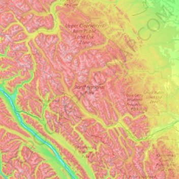
Название: Топографическая карта Banff National Park, высота, рельеф.
Местонахождение: Banff National Park, Alberta, Canada (50.70506 -117.31712 52.27145 -115.16491)
Средняя высота: 1 848 м
Минимальная высота: 773 м
Максимальная высота: 3 472 м
Сделать пожертвование
Другие топографические карты
Нажмите на карту, чтобы просмотреть ее топографию, ее высоту и ее рельеф.
Banff
Canada > Alberta > Banff > Banff
Banff is a town within Banff National Park in Alberta, Canada. It is located in Alberta's Rockies along the Trans-Canada Highway, approximately 126 km (78 mi) west of Calgary and 58 km (36 mi) east of Lake Louise. At 1,400 to 1,630 m (4,590 to 5,350 ft) above sea level, Banff is the community with the second…
Средняя высота: 1 615 м
Canmore
Canada > Alberta > Town of Canmore
Elevation Place opened in April 2013 as Canmore's new recreation facility. Construction of the facility began in 2012 to replace the Canmore Recreation Centre (the community's old facility). The facility offers an 8-lane 25m lap pool, a world class climbing wall developed by Walltopia, two cardio rooms, a…
Средняя высота: 1 565 м
Nose Hill Park
Names currently associated with topographical features in and near Nose Hill Park reflect the impact of the European newcomers and European trade goods on the Peigan. For example, Spy Hill, the westward extension of Nose Hill, derived its present name from the aboriginal practice of communicating with distant…
Средняя высота: 1 174 м
Сделать пожертвование
Lake Louise
Canada > Alberta > Improvement District No. 9
Lake Louise is a hamlet within Banff National Park in Alberta, Canada. Named after Princess Louise, Duchess of Argyll, it lies in Alberta's Rockies on the Bow River, 3 km (1.9 mi) northeast of the lake that shares its name. Initially settled in 1884 as an outpost for the Canadian Pacific Railway, Lake Louise…
Средняя высота: 1 617 м
Lethbridge
Canada > Alberta > Lethbridge
Its high elevation of 929 m (3,047.9 ft) and close proximity to the Rocky Mountains provides Lethbridge with cooler summers than other locations in the Canadian Prairies. These factors protect the city from strong northwest and southwest winds and contribute to frequent chinook winds during the winter.…
Средняя высота: 918 м
Сделать пожертвование
Wimborne
Canada > Alberta > Kneehill County
Wimborne is a hamlet in southern Alberta, Canada within Kneehill County. It is located approximately 58 km (36 mi) southeast of Red Deer. It has an elevation of 975 m (3,199 ft).
Средняя высота: 962 м
Сделать пожертвование
Grande Prairie
Canada > Alberta > Grande Prairie
Grande Prairie is located just north of the 55th parallel north, and is 465 km (289 mi) northwest of Edmonton, lying at an elevation of 669 m (2,195 ft) above sea level. The city is surrounded by farmland to the north, east, and west. To the south lies a vast boreal forest with aspen, tamarack, lodgepole pine,…
Средняя высота: 668 м
Cochrane
Canada > Alberta > Town of Cochrane > Cochrane
Cochrane is situated at the base of Big Hill in the Bow River Valley. It sits at an elevation of 1,186 m (3,891 ft). The town is intersected by Highway 1A and Highway 22. Cochrane has a reputation for its western culture, which can easily be felt when one wanders the streets (particularly Main Street). The…
Средняя высота: 1 205 м
Сделать пожертвование
La Glace
Canada > Alberta > County of Grande Prairie
La Glace is a hamlet in northern Alberta, Canada within the County of Grande Prairie No. 1. It is located along Highway 59 between Sexsmith and Valhalla Centre and has an elevation of 735 metres (2,411 ft).
Средняя высота: 738 м
Сделать пожертвование
Сделать пожертвование
Сделать пожертвование
Сделать пожертвование
Сделать пожертвование
Peace River
Canada > Alberta > Peace River
Physiographically, the Town of Peace River lies within the Peace River Formation, a stratigraphical unit of middle Albian age in the Western Canadian Sedimentary Basin. The area developed on sediments of the former lake bottom of Glacial Lake Peace, which covered most of the areas in the region that were below…
Средняя высота: 433 м
Nordegg
Canada > Alberta > Clearwater County
Nordegg has a subarctic climate (Dfc) which can be considered a subalpine climate due to its altitude with locations on the same latitude having warmer climates. Summers are mild, with a few warm days sprinkled in here and there, while winters are cold and snowy.
Средняя высота: 1 475 м
Сделать пожертвование
West Bragg Creek Provincial Recreation Area
Canada > Alberta > Kananaskis Improvement District
Средняя высота: 1 467 м
Сделать пожертвование
Сделать пожертвование
Nordegg
Canada > Alberta > Clearwater County
Nordegg has a subarctic climate (Dfc) which can be considered a subalpine climate due to its altitude with locations on the same latitude having warmer climates. Summers are mild, with a few warm days sprinkled in here and there, while winters are cold and snowy.
Средняя высота: 1 475 м
Сделать пожертвование
Сделать пожертвование
Сделать пожертвование
Сделать пожертвование
Mount Columbia
Canada > Alberta > Improvement District No. 12
Mount Columbia is a mountain located in the Winston Churchill Range of the Rocky Mountains. It is the highest point in Alberta, Canada, and is second only to Mount Robson for height and topographical prominence in the Canadian Rockies. It is located on the border between Alberta and British Columbia on the…
Средняя высота: 2 841 м
Сделать пожертвование
Сделать пожертвование
Marten Beach Subdivision
Canada > Alberta > Municipal District of Lesser Slave River
Средняя высота: 585 м
Сделать пожертвование
Сделать пожертвование
Сделать пожертвование
Сделать пожертвование
Moraine Lake
Canada > Alberta > Improvement District No. 9
Moraine Lake is a snow and glacially fed alpine lake in Banff National Park, 14 kilometres (8.7 mi) outside the village of Lake Louise, Alberta, Canada. It is situated in the Valley of the Ten Peaks, at an elevation of approximately 1,884 metres (6,181 ft). The lake has a surface area of 50 hectares (120…
Средняя высота: 2 101 м
Сделать пожертвование
Сделать пожертвование
Сделать пожертвование