
Сделать пожертвование
Топографическая карта Lethbridge
Нажмите на карту, чтобы отобразить высоту.
Сделать пожертвование
Lethbridge
Its high elevation of 929 m (3,047.9 ft) and close proximity to the Rocky Mountains provides Lethbridge with cooler summers than other locations in the Canadian Prairies. These factors protect the city from strong northwest and southwest winds and contribute to frequent chinook winds during the winter. Lethbridge winters have the highest temperatures in the prairies, reducing the severity and duration of winter cold periods and resulting in fewer days with snow cover. The average daytime temperature peaks by the end of July/beginning of August, when it reaches 26.4 °C (79.5 °F). The city's temperature reaches a maximum high of 35 °C (95 °F) or greater on average once or twice a year.
Сделать пожертвование
Об этой карте
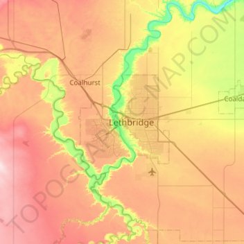
Название: Топографическая карта Lethbridge, высота, рельеф.
Местонахождение: Lethbridge, City of Lethbridge, Alberta, T1J 4L3, Canada (49.53429 -113.01156 49.85429 -112.69156)
Средняя высота: 918 м
Минимальная высота: 782 м
Максимальная высота: 1 056 м
Сделать пожертвование
Другие топографические карты
Нажмите на карту, чтобы просмотреть ее топографию, ее высоту и ее рельеф.