
Сделать пожертвование
Топографическая карта Madras
Нажмите на карту, чтобы отобразить высоту.
Сделать пожертвование
Об этой карте
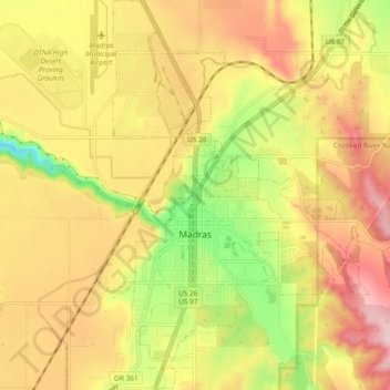
Название: Топографическая карта Madras, высота, рельеф.
Местонахождение: Madras, Jefferson County, Oregon, United States (44.60664 -121.15065 44.67345 -121.08754)
Средняя высота: 739 м
Минимальная высота: 618 м
Максимальная высота: 836 м
Сделать пожертвование
Другие топографические карты
Нажмите на карту, чтобы просмотреть ее топографию, ее высоту и ее рельеф.
Black Butte
United States > Oregon > Jefferson County
According to the U.S. National Geodetic Survey and scientists from the United States Geological Survey, Black Butte has an elevation of 6,436 feet (1,962 m); the Geographic Names Information System database lists its elevation as 6,430 feet (1,960 m), while Oregon Geographic Names lists its elevation at 6,415…
Средняя высота: 1 514 м
Mount Jefferson
United States > Oregon > Jefferson County
The second tallest mountain in the U.S. state of Oregon after Mount Hood, Mount Jefferson lies within Jefferson, Linn, and Marion counties, in the central part of the state. Reaching an elevation of 10,497 feet (3,199 m), the volcano has a proximal relief of 4,890 feet (1,490 m). It is not usually visible from…
Средняя высота: 2 537 м
Сделать пожертвование