
Топографическая карта Stonehill
Нажмите на карту, чтобы отобразить высоту.
Об этой карте
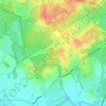
Название: Топографическая карта Stonehill, высота, рельеф.
Местонахождение: Stonehill, Surrey Heath, Surrey, England, KT16 0EW, United Kingdom (51.36147 -0.56048 51.36157 -0.56038)
Средняя высота: 40 м
Минимальная высота: 19 м
Максимальная высота: 69 м
Другие топографические карты
Нажмите на карту, чтобы просмотреть ее топографию, ее высоту и ее рельеф.
Chobham Common
United Kingdom > England > Surrey > Surrey Heath > Chobham > Brick Hill
Средняя высота: 49 м
Frimley Lodge Park
United Kingdom > England > Surrey > Surrey Heath > Frimley Green
Средняя высота: 80 м
Chobham
United Kingdom > England > Surrey > Surrey Heath
The rolling basin below reaches lowest elevations of between 30 metres (98 ft) in the centre of the west and 20 metres (66 ft) where the rivers join in the centre of the east. The rivers at the western point are less than 100 metres (330 ft) apart; to the east end of the parish where the parish adjoins the…
Средняя высота: 43 м