
Сделать пожертвование
Топографическая карта Chobham
Нажмите на карту, чтобы отобразить высоту.
Сделать пожертвование
Chobham
The rolling basin below reaches lowest elevations of between 30 metres (98 ft) in the centre of the west and 20 metres (66 ft) where the rivers join in the centre of the east. The rivers at the western point are less than 100 metres (330 ft) apart; to the east end of the parish where the parish adjoins the landscape of the McLaren Technology Centre the rivers are finally merged along that boundary.
Сделать пожертвование
Об этой карте
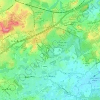
Название: Топографическая карта Chobham, высота, рельеф.
Местонахождение: Chobham, Surrey Heath, Surrey, England, United Kingdom (51.33363 -0.64098 51.39246 -0.54851)
Средняя высота: 43 м
Минимальная высота: 19 м
Максимальная высота: 99 м
Сделать пожертвование
Другие топографические карты
Нажмите на карту, чтобы просмотреть ее топографию, ее высоту и ее рельеф.
Camberley
United Kingdom > England > Surrey > Surrey Heath
The Staff College, to the north of Camberley town centre, is part of the Joint Services Command and Staff College, which provides training and education for established officers in the British Armed Forces and civil servants in the Ministry of Defence. The institution has its origins in the Royal Military…
Средняя высота: 88 м
Сделать пожертвование
Frimley Lodge Park
United Kingdom > England > Surrey > Surrey Heath > Frimley Green
Средняя высота: 80 м
Сделать пожертвование
Сделать пожертвование
Сделать пожертвование
Camberley
United Kingdom > England > Surrey > Surrey Heath
The Staff College, to the north of Camberley town centre, is part of the Joint Services Command and Staff College, which provides training and education for established officers in the British Armed Forces and civil servants in the Ministry of Defence. The institution has its origins in the Royal Military…
Средняя высота: 88 м