
Сделать пожертвование
Топографическая карта Alta
Нажмите на карту, чтобы отобразить высоту.
Сделать пожертвование
Alta
Alta experiences a high altitude humid continental climate (Köppen Dfb), which borders on a subalpine climate (Dfc), due to its high elevation. Due to its proximity to the Great Salt Lake, the town receives very heavy snows, averaging over 507 inches (12.9 m) per year. During the very wet season of 1982/1983, Alta received as much as 900 inches (23 m) of snow, leading to record flooding of Wasatch streams as the snow melted during May and June that year. Alta's total precipitation of 108.54 inches (2,756.9 mm) during 1983 is a record for a calendar year in any state of the Mountain West; strangely Villanueva only 675 miles (1,086 km) away recorded only 0.91 inches (23.1 mm), which is a record low for New Mexico, in that same year.
Сделать пожертвование
Об этой карте
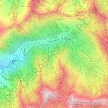
Название: Топографическая карта Alta, высота, рельеф.
Местонахождение: Alta, Salt Lake County, Utah, United States (40.56441 -111.65273 40.60326 -111.59808)
Средняя высота: 2 912 м
Минимальная высота: 2 437 м
Максимальная высота: 3 369 м
Сделать пожертвование
Другие топографические карты
Нажмите на карту, чтобы просмотреть ее топографию, ее высоту и ее рельеф.
Jordan River OHV/ Modelport State Park
United States > Utah > Salt Lake County > Salt Lake City
Средняя высота: 1 286 м
Сделать пожертвование
Сделать пожертвование
Сделать пожертвование
Сделать пожертвование
Сделать пожертвование
Salt Lake City
United States > Utah > Salt Lake County > Salt Lake City
Salt Lake City has an area of 110.4 square miles (286 km2) and an average elevation of 4,327 feet (1,319 m) above sea level. The lowest point within the boundaries of the city is 4,210 feet (1,280 m) near the Jordan River and the Great Salt Lake, and the highest is Grandview Peak, at 9,410 feet (2,868 m).
Средняя высота: 1 625 м
Meridian Peak
United States > Utah > Salt Lake County > Salt Lake City
Meridian Peak can be found at the southern end of Elliot Ridge Trail. It can be reached by ascending several hiking trails into the Gore Range. Surprise Lake Trail goes south for 2.6 miles to Surprise Lake, then the Gore Range Trail continues west for 1.9 miles to a junction with the Upper Cataract Lake and…
Средняя высота: 1 698 м
Сделать пожертвование
Brighton
United States > Utah > Salt Lake County
Brighton has a high-altitude cold continental climate (Köppen Dsb/Dsc), with dry summers and very snowy winters.
Средняя высота: 2 852 м
Сделать пожертвование