
Сделать пожертвование
Топографическая карта Brighton
Нажмите на карту, чтобы отобразить высоту.
Сделать пожертвование
Brighton
Brighton has a high-altitude cold continental climate (Köppen Dsb/Dsc), with dry summers and very snowy winters.
Сделать пожертвование
Об этой карте
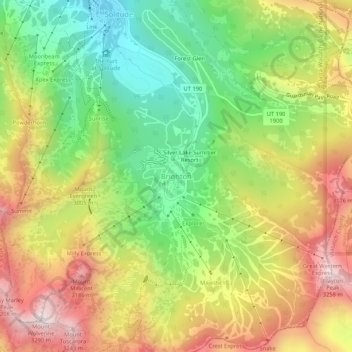
Название: Топографическая карта Brighton, высота, рельеф.
Местонахождение: Brighton, Salt Lake County, Utah, United States (40.58182 -111.60331 40.62182 -111.56331)
Средняя высота: 2 852 м
Минимальная высота: 2 487 м
Максимальная высота: 3 271 м
Сделать пожертвование
Другие топографические карты
Нажмите на карту, чтобы просмотреть ее топографию, ее высоту и ее рельеф.
Salt Lake City
United States > Utah > Salt Lake County
Salt Lake City's topography is characterized by a striking contrast between its flat valley floor and the surrounding rugged mountains. The city is situated in the Salt Lake Valley, with an average elevation of approximately 4,237 feet above sea level, making it one of the higher major cities in the United…
Средняя высота: 1 592 м
South Jordan
United States > Utah > Salt Lake County
The relative flatness of South Jordan is due to lacustrine sediments of a pleistocene lake called Lake Bonneville. Lake Bonneville existed from 75,000 to 8,000 years ago; at its peak some 30,000 years ago, the lake reached an elevation of 5,200 feet (1,600 m) above sea level and had a surface area of 19,800…
Средняя высота: 1 407 м
Сделать пожертвование
West Jordan
United States > Utah > Salt Lake County
West Jordan is a city in Salt Lake County, Utah, United States. It is a suburb of Salt Lake City and has a mixed economy. According to the 2020 Census, the city had a population of 116,961, placing it as the third most populous in the state. The city occupies the southwest end of the Salt Lake Valley at an…
Средняя высота: 1 372 м
Salt Lake City
United States > Utah > Salt Lake County
Salt Lake City has an area of 110.4 square miles (286 km2) and an average elevation of 4,327 feet (1,319 m) above sea level. The lowest point within the boundaries of the city is 4,210 feet (1,280 m) near the Jordan River and the Great Salt Lake, and the highest is Grandview Peak, at 9,410 feet (2,868 m).
Средняя высота: 1 592 м
Draper
United States > Utah > Salt Lake County
Draper's climate is roughly identical to other Salt Lake City suburbs. However, due to being further away from the Great Salt Lake, varied elevation, and from the downtown urban heat island effect, Draper experiences a slightly drier winter and more extremes in temperatures.
Средняя высота: 1 570 м
Сделать пожертвование
Jordan River OHV/ Modelport State Park
United States > Utah > Salt Lake County > Salt Lake City
Средняя высота: 1 286 м
Сделать пожертвование
Salt Lake City
United States > Utah > Salt Lake County
Salt Lake City has an area of 110.4 square miles (286 km2) and an average elevation of 4,327 feet (1,319 m) above sea level. The lowest point within the boundaries of the city is 4,210 feet (1,280 m) near the Jordan River and the Great Salt Lake, and the highest is Grandview Peak, at 9,410 feet (2,868 m).
Средняя высота: 1 592 м
Brighton
United States > Utah > Salt Lake County
Brighton has a high-altitude cold continental climate (Köppen Dsb/Dsc), with dry summers and very snowy winters.
Средняя высота: 2 774 м
Сделать пожертвование
Salt Lake City
United States > Utah > Salt Lake County
Salt Lake City has an area of 110.4 square miles (286 km2) and an average elevation of 4,327 feet (1,319 m) above sea level. The lowest point within the boundaries of the city is 4,210 feet (1,280 m) near the Jordan River and the Great Salt Lake, and the highest is Grandview Peak, at 9,410 feet (2,868 m).
Средняя высота: 1 592 м
Murray
United States > Utah > Salt Lake County
According to the United States Census Bureau, the city has a total area of 9.6 square miles (25 km2), all land. Murray is located in the heart of the Salt Lake Valley. The city is nearly built out with a broad mix of commercial, residential and industrial uses. The topography is generally gentle, sloping…
Средняя высота: 1 321 м
Сделать пожертвование
Taylorsville
United States > Utah > Salt Lake County
The land on which Taylorsville is located is part of an interconnected alluvial plain that was formed by the wearing down of the Wasatch and Oquirrh Mountains to the east and west. Beneath the surface, Taylorsville sits on more than a kilometer of unconsolidated rock, sand, and clay. The inactive Taylorsville…
Средняя высота: 1 325 м
Сделать пожертвование
Brighton
United States > Utah > Salt Lake County
Brighton has a high-altitude cold continental climate (Köppen Dsb/Dsc), with dry summers and very snowy winters.
Средняя высота: 2 774 м
Сделать пожертвование
Taylorsville
United States > Utah > Salt Lake County
The land on which Taylorsville is located is part of an interconnected alluvial plain that was formed by the wearing down of the Wasatch and Oquirrh Mountains to the east and west. Beneath the surface, Taylorsville sits on more than a kilometer of unconsolidated rock, sand, and clay. The inactive Taylorsville…
Средняя высота: 1 325 м
Draper
United States > Utah > Salt Lake County
Draper's climate is roughly identical to other Salt Lake City suburbs. However, due to being further away from the Great Salt Lake, varied elevation, and from the downtown urban heat island effect, Draper experiences a slightly drier winter and more extremes in temperatures.
Средняя высота: 1 570 м
Alta
United States > Utah > Salt Lake County
Alta experiences a high altitude humid continental climate (Köppen Dfb), which borders on a subalpine climate (Dfc), due to its high elevation. Due to its proximity to the Great Salt Lake, the town receives very heavy snows, averaging over 507 inches (12.9 m) per year. During the very wet season of 1982/1983,…
Средняя высота: 2 912 м
Сделать пожертвование
Murray
United States > Utah > Salt Lake County
According to the United States Census Bureau, the city has a total area of 9.6 square miles (24.9 km2), all land. Murray is located in the heart of the Salt Lake Valley. The city is nearly built out with a broad mix of commercial, residential and industrial uses. The topography is generally gentle, sloping…
Средняя высота: 1 321 м
Draper
United States > Utah > Salt Lake County
Draper's climate is roughly identical to other Salt Lake City suburbs. However, due to being further away from the Great Salt Lake, varied elevation, and from the downtown urban heat island effect, Draper experiences a slightly drier winter and more extremes in temperatures.
Средняя высота: 1 570 м
Taylorsville
United States > Utah > Salt Lake County
The land on which Taylorsville is located is part of an interconnected alluvial plain that was formed by the wearing down of the Wasatch and Oquirrh Mountains to the east and west. Beneath the surface, Taylorsville sits on more than a kilometer of unconsolidated rock, sand, and clay. The inactive Taylorsville…
Средняя высота: 1 325 м
Murray
United States > Utah > Salt Lake County
According to the United States Census Bureau, the city has a total area of 9.6 square miles (24.9 km2), all land. Murray is located in the heart of the Salt Lake Valley. The city is nearly built out with a broad mix of commercial, residential and industrial uses. The topography is generally gentle, sloping…
Средняя высота: 1 321 м
Сделать пожертвование
Emigration Canyon
United States > Utah > Salt Lake County
Emigration Canyon is one of the most accessible canyon rides from Salt Lake City. With a length of 7.7 miles and an average grade of 5 percent, there are approximately 1,300 feet of elevation gain from the mouth to the top, which cyclists often refer to as "Little Mountain". There is a good shoulder to ride…
Средняя высота: 1 983 м
Murray
United States > Utah > Salt Lake County
According to the United States Census Bureau, the city has a total area of 9.6 square miles (24.9 km2), all land. Murray is located in the heart of the Salt Lake Valley. The city is nearly built out with a broad mix of commercial, residential and industrial uses. The topography is generally gentle, sloping…
Средняя высота: 1 321 м
Сделать пожертвование
Salt Lake City
United States > Utah > Salt Lake County
Salt Lake City has an area of 110.4 square miles (286 km2) and an average elevation of 4,327 feet (1,319 m) above sea level. The lowest point within the boundaries of the city is 4,210 feet (1,280 m) near the Jordan River and the Great Salt Lake, and the highest is Grandview Peak, at 9,410 feet (2,868 m).
Средняя высота: 1 592 м
Taylorsville
United States > Utah > Salt Lake County
The land on which Taylorsville is located is part of an interconnected alluvial plain that was formed by the wearing down of the Wasatch and Oquirrh Mountains to the east and west. Beneath the surface, Taylorsville sits on more than a kilometer of unconsolidated rock, sand, and clay. The inactive Taylorsville…
Средняя высота: 1 325 м
Сделать пожертвование
Bluffdale
United States > Utah > Salt Lake County
Bluffdale has an area of 10.22 square miles (26.47 km2) and an average elevation of 4,436 feet (1,352 m) above sea level. Bluffdale is predominately located in Salt Lake County, though a portion of the city is in Utah County. Bluffdale shares city borders with Herriman to the west, Riverton to the north,…
Средняя высота: 1 468 м
South Salt Lake
United States > Utah > Salt Lake County
The city is bordered by the Jordan River on the west, 500 East and 700 East on the east, 2100 South on the north, and 3900 South on the south. West Valley City lies to the west, Salt Lake City to the north, northeast, and east; and Millcreek to the east, south, and southeast. Because of its location next to…
Средняя высота: 1 303 м
Salt Lake City
United States > Utah > Salt Lake County
Salt Lake City has an area of 110.4 square miles (286 km2) and an average elevation of 4,327 feet (1,319 m) above sea level. The lowest point within the boundaries of the city is 4,210 feet (1,280 m) near the Jordan River and the Great Salt Lake, and the highest is Grandview Peak, at 9,410 feet (2,868 m).
Средняя высота: 1 592 м
Сделать пожертвование
Salt Lake City
United States > Utah > Salt Lake County
Salt Lake City has an area of 110.4 square miles (286 km2) and an average elevation of 4,327 feet (1,319 m) above sea level. The lowest point within the boundaries of the city is 4,210 feet (1,280 m) near the Jordan River and the Great Salt Lake, and the highest is Grandview Peak, at 9,410 feet (2,868 m).
Средняя высота: 1 592 м
South Jordan
United States > Utah > Salt Lake County
The relative flatness of South Jordan is due to lacustrine sediments of a pleistocene lake called Lake Bonneville. Lake Bonneville existed from 75,000 to 8,000 years ago; at its peak some 30,000 years ago, the lake reached an elevation of 5,200 feet (1,600 m) above sea level and had a surface area of 19,800…
Средняя высота: 1 407 м
Сделать пожертвование
West Jordan
United States > Utah > Salt Lake County
West Jordan is a city in Salt Lake County, Utah, United States. It is a suburb of Salt Lake City and has a mixed economy. According to the 2020 Census, the city had a population of 116,961, placing it as the third most populous in the state. The city occupies the southwest end of the Salt Lake Valley at an…
Средняя высота: 1 372 м
Alta
United States > Utah > Salt Lake County
Alta experiences a high altitude humid continental climate (Köppen Dfb), which borders on a subalpine climate (Dfc), due to its high elevation. Due to its proximity to the Great Salt Lake, the town receives very heavy snows, averaging over 507 inches (12.9 m) per year. During the very wet season of 1982/1983,…
Средняя высота: 2 912 м
Сделать пожертвование
West Jordan
United States > Utah > Salt Lake County
West Jordan is a city in Salt Lake County, Utah, United States. It is a suburb of Salt Lake City and has a mixed economy. According to the 2020 Census, the city had a population of 116,961, placing it as the third most populous in the state. The city occupies the southwest end of the Salt Lake Valley at an…
Средняя высота: 1 372 м
South Jordan
United States > Utah > Salt Lake County
The relative flatness of South Jordan is due to lacustrine sediments of a pleistocene lake called Lake Bonneville. Lake Bonneville existed from 75,000 to 8,000 years ago; at its peak some 30,000 years ago, the lake reached an elevation of 5,200 feet (1,600 m) above sea level and had a surface area of 19,800…
Средняя высота: 1 407 м