Топографическая карта Aldsworth
Интерактивная карта
Нажмите на карту, чтобы отобразить высоту.
Об этой карте
![Топографическая карта Aldsworth, высота, рельеф](/pub/maps/node/gvnx/kg4t8gt/thumbnail.jpg)
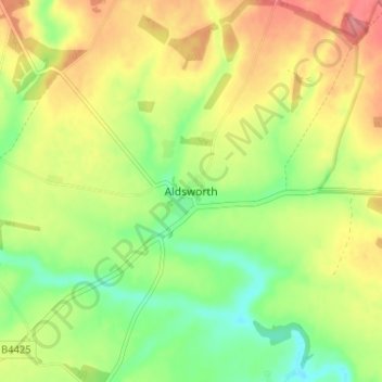
Название: Топографическая карта Aldsworth, высота, рельеф.
Местонахождение: Aldsworth, Cotswold District, Gloucestershire, England, GL54 3QX, United Kingdom (51.76954 -1.79471 51.80954 -1.75471)
Средняя высота: 142 м
Минимальная высота: 104 м
Максимальная высота: 182 м
Другие топографические карты
Нажмите на карту, чтобы просмотреть ее топографию, ее высоту и ее рельеф.
![Топографическая карта Baunton, высота, рельеф](/pub/maps/relation/xp5k/p6vbcz/icon.jpg)
Baunton
United Kingdom > England > Gloucestershire > Cotswold District > Baunton
Baunton, Cotswold District, Gloucestershire, England, United Kingdom
Средняя высота: 146 м
![Топографическая карта Condicote, высота, рельеф](/pub/maps/node/z6t6/2nvb85k/icon.jpg)
Condicote
United Kingdom > England > Gloucestershire > Cotswold District
Condicote, Cotswold District, Gloucestershire, England, GL54 1ES, United Kingdom
Средняя высота: 201 м
![Топографическая карта Lower Slaughter, высота, рельеф](/pub/maps/node/qgt/kg7z2gt/icon.jpg)
Lower Slaughter
United Kingdom > England > Gloucestershire > Cotswold District
Lower Slaughter, Cotswold District, Gloucestershire, England, GL54 2HX, United Kingdom
Средняя высота: 160 м
![Топографическая карта Cutsdean, высота, рельеф](/pub/maps/relation/hhm2/c4t3nx/icon.jpg)
Cutsdean
United Kingdom > England > Gloucestershire > Cotswold District
Cutsdean, Cotswold District, Gloucestershire, England, United Kingdom
Средняя высота: 233 м
![Топографическая карта Dowdeswell, высота, рельеф](/pub/maps/relation/3v1h/7jh18/icon.jpg)
Dowdeswell
United Kingdom > England > Gloucestershire > Cotswold District
Dowdeswell, Cotswold District, Gloucestershire, England, United Kingdom
Средняя высота: 209 м
![Топографическая карта Daylesford, высота, рельеф](/pub/maps/node/34dn/8ctc49m/icon.jpg)
Daylesford
United Kingdom > England > Gloucestershire > Cotswold District
Daylesford, Cotswold District, Gloucestershire, England, GL56 0YG, United Kingdom
Средняя высота: 137 м
![Топографическая карта Barnsley, высота, рельеф](/pub/maps/node/sns8/qqrx5tf/icon.jpg)
Barnsley
United Kingdom > England > Gloucestershire > Cotswold District
Barnsley, Cotswold District, Gloucestershire, England, GL7 5EF, United Kingdom
Средняя высота: 135 м
![Топографическая карта Maugersbury, высота, рельеф](/pub/maps/node/hldn/75j47gt/icon.jpg)
Maugersbury
United Kingdom > England > Gloucestershire > Cotswold District
Maugersbury, Cotswold District, Gloucestershire, England, GL54 1HR, United Kingdom
Средняя высота: 166 м
![Топографическая карта Duntisbourne Abbots, высота, рельеф](/pub/maps/node/6bmt/sbn3g3q/icon.jpg)
Duntisbourne Abbots
United Kingdom > England > Gloucestershire > Cotswold District
Duntisbourne Abbots, Cotswold District, Gloucestershire, England, GL7 7JN, United Kingdom
Средняя высота: 204 м
![Топографическая карта Tarlton, высота, рельеф](/pub/maps/node/7518/gnfrjnh/icon.jpg)
Tarlton
United Kingdom > England > Gloucestershire > Cotswold District
Tarlton, Rodmarton, Cotswold District, Gloucestershire, England, GL7 6PA, United Kingdom
Средняя высота: 144 м
![Топографическая карта Bagpath, высота, рельеф](/pub/maps/node/xhf3/cmx8scz/icon.jpg)
Bagpath
United Kingdom > England > Gloucestershire > Cotswold District
Bagpath, Kingscote, Cotswold District, Gloucestershire, England, GL8 8YG, United Kingdom
Средняя высота: 198 м
![Топографическая карта Cerney Wick, высота, рельеф](/pub/maps/node/31dn/pl8nrkl/icon.jpg)
Cerney Wick
United Kingdom > England > Gloucestershire > Cotswold District
Cerney Wick, Cotswold District, Gloucestershire, England, GL7 5QH, United Kingdom
Средняя высота: 85 м
![Топографическая карта Birdlip, высота, рельеф](/pub/maps/relation/p7cz/vbnts8/icon.jpg)
Birdlip
United Kingdom > England > Gloucestershire > Cotswold District
Birdlip, Cotswold District, Gloucestershire, England, United Kingdom
Средняя высота: 261 м
![Топографическая карта Worcestershire (detached), высота, рельеф](/pub/maps/relation/klzs/vndhnx/icon.jpg)
Worcestershire (detached)
United Kingdom > England > Gloucestershire > Cotswold District
Worcestershire (detached), Cotswold District, Gloucestershire, West Midlands Combined Authority, England, United Kingdom
Средняя высота: 103 м
![Топографическая карта Cirencester, высота, рельеф](/pub/maps/relation/z85k/fbsdgp/icon.jpg)
Cirencester
United Kingdom > England > Gloucestershire > Cotswold District > Chesterton
Cirencester, Chesterton, Cotswold District, Gloucestershire, England, United Kingdom
Средняя высота: 128 м
![Топографическая карта Syde, высота, рельеф](/pub/maps/node/ck3q/bq5l2b3/icon.jpg)
Syde
United Kingdom > England > Gloucestershire > Cotswold District
Syde, Cotswold District, Gloucestershire, England, GL53 9PN, United Kingdom
Средняя высота: 238 м
![Топографическая карта Taylors Hill, высота, рельеф](/pub/maps/node/wpnx/6n6g8tj/icon.jpg)
Taylors Hill
United Kingdom > England > Gloucestershire > Cotswold District
Taylors Hill, Cotswold District, Gloucestershire, England, GL54 4BJ, United Kingdom
Средняя высота: 237 м
![Топографическая карта Mickleton, высота, рельеф](/pub/maps/node/kcb3/jhbsfdn/icon.jpg)
Mickleton
United Kingdom > England > Gloucestershire > Cotswold District
Mickleton, Cotswold District, Gloucestershire, England, GL55 6TS, United Kingdom
Средняя высота: 101 м
![Топографическая карта Trewsbury Mead, высота, рельеф](/pub/maps/node/t8m2/sgmnl6cz/icon.jpg)
Trewsbury Mead
United Kingdom > England > Gloucestershire > Cotswold District
Trewsbury Mead, Coates, Cotswold District, Gloucestershire, England, GL7 6NY, United Kingdom
Средняя высота: 122 м
![Топографическая карта North Cerney, высота, рельеф](/pub/maps/node/14m2/3r3g93q/icon.jpg)
North Cerney
United Kingdom > England > Gloucestershire > Cotswold District
North Cerney, Cotswold District, Gloucestershire, England, GL7 7BZ, United Kingdom
Средняя высота: 179 м
![Топографическая карта Hatherop, высота, рельеф](/pub/maps/node/3ndn/m84hb3q/icon.jpg)
Hatherop
United Kingdom > England > Gloucestershire > Cotswold District
Hatherop, Cotswold District, Gloucestershire, England, GL7 3NA, United Kingdom
Средняя высота: 120 м
![Топографическая карта Stow-on-the-Wold, высота, рельеф](/pub/maps/node/4wrr/h14l57/icon.jpg)
Stow-on-the-Wold
United Kingdom > England > Gloucestershire > Cotswold District
Stow-on-the-Wold, Cotswold District, Gloucestershire, England, GL54 1AB, United Kingdom
Средняя высота: 163 м
![Топографическая карта Botany Bay Wood, высота, рельеф](/pub/maps/way/kz1h/6thkpgp/icon.jpg)
Botany Bay Wood
United Kingdom > England > Gloucestershire > Cotswold District > Stow-on-the-Wold
Botany Bay Wood, Maugersbury, Stow-on-the-Wold, Cotswold District, Gloucestershire, England, United Kingdom
Средняя высота: 171 м
![Топографическая карта Eastleach Martin, высота, рельеф](/pub/maps/node/mzdn/vvg24prr/icon.jpg)
Eastleach Martin
United Kingdom > England > Gloucestershire > Cotswold District > Eastleach Turville
Eastleach Martin, Eastleach, Eastleach Turville, Cotswold District, Gloucestershire, England, GL7 3NW, United Kingdom
Средняя высота: 111 м
![Топографическая карта Chipping Campden, высота, рельеф](/pub/maps/relation/4jdn/fb9sgp/icon.jpg)
Chipping Campden
United Kingdom > England > Gloucestershire > Cotswold District
Chipping Campden, Cotswold District, Gloucestershire, England, United Kingdom
Средняя высота: 191 м
![Топографическая карта Saintbury, высота, рельеф](/pub/maps/node/glkl/sgn4j5k/icon.jpg)
Saintbury
United Kingdom > England > Gloucestershire > Cotswold District
Saintbury, Cotswold District, Gloucestershire, England, WR12 7PX, United Kingdom
Средняя высота: 124 м
![Топографическая карта Coberley, высота, рельеф](/pub/maps/node/7bkl/w44tfmt/icon.jpg)
Coberley
United Kingdom > England > Gloucestershire > Cotswold District
Coberley, Cotswold District, Gloucestershire, England, GL53 9QZ, United Kingdom
Средняя высота: 240 м
![Топографическая карта Somerford Keynes, высота, рельеф](/pub/maps/node/mnmt/9vvn8dn/icon.jpg)
Somerford Keynes
United Kingdom > England > Gloucestershire > Cotswold District
Somerford Keynes, Cotswold District, Gloucestershire, England, GL7 6DR, United Kingdom
Средняя высота: 91 м
![Топографическая карта Lechlade, высота, рельеф](/pub/maps/node/k1f3/366bnx/icon.jpg)
Lechlade
United Kingdom > England > Gloucestershire > Cotswold District
Lechlade, Cotswold District, Gloucestershire, England, GL7 3BY, United Kingdom
Средняя высота: 81 м
![Топографическая карта Naunton, высота, рельеф](/pub/maps/node/7914/jbxj2kl/icon.jpg)
Naunton
United Kingdom > England > Gloucestershire > Cotswold District
Naunton, Cotswold District, Gloucestershire, England, GL54 3AS, United Kingdom
Средняя высота: 201 м
![Топографическая карта Knap House Quarry, Birdlip, высота, рельеф](/pub/maps/way/f4s8/szd6srb3/icon.jpg)
Knap House Quarry, Birdlip
United Kingdom > England > Gloucestershire > Cotswold District > Birdlip
Knap House Quarry, Birdlip, Cowley, Birdlip, Cotswold District, Gloucestershire, England, United Kingdom
Средняя высота: 222 м
![Топографическая карта South Cerney, высота, рельеф](/pub/maps/relation/t8tj/db2s1h/icon.jpg)
South Cerney
United Kingdom > England > Gloucestershire > Cotswold District > South Cerney
South Cerney, Cotswold District, Gloucestershire, England, United Kingdom
Средняя высота: 93 м
![Топографическая карта Withington, высота, рельеф](/pub/maps/relation/623l/8x4z51/icon.jpg)
Withington
United Kingdom > England > Gloucestershire > Cotswold District
Withington, Cotswold District, Gloucestershire, England, United Kingdom
Средняя высота: 212 м
![Топографическая карта Down Ampney, высота, рельеф](/pub/maps/node/49cz/9xb1snh/icon.jpg)
Down Ampney
United Kingdom > England > Gloucestershire > Cotswold District
Down Ampney, Cotswold District, Gloucestershire, England, GL7 5QR, United Kingdom
Средняя высота: 85 м
![Топографическая карта Weston-sub-Edge, высота, рельеф](/pub/maps/node/d18/4f4p8nh/icon.jpg)
Weston-sub-Edge
United Kingdom > England > Gloucestershire > Cotswold District
Weston-sub-Edge, Cotswold District, Gloucestershire, England, GL55 6QZ, United Kingdom
Средняя высота: 98 м
![Топографическая карта Compton Abdale, высота, рельеф](/pub/maps/node/97t6/gg4jxs8/icon.jpg)
Compton Abdale
United Kingdom > England > Gloucestershire > Cotswold District
Compton Abdale, Cotswold District, Gloucestershire, England, GL54 4DS, United Kingdom
Средняя высота: 212 м
![Топографическая карта Broad Campden, высота, рельеф](/pub/maps/node/4d3q/wjxrnz4/icon.jpg)
Broad Campden
United Kingdom > England > Gloucestershire > Cotswold District
Broad Campden, Cotswold District, Gloucestershire, England, GL55 6UU, United Kingdom
Средняя высота: 167 м
![Топографическая карта Tetbury, высота, рельеф](/pub/maps/relation/g1t6/lwjsmt/icon.jpg)
Tetbury
United Kingdom > England > Gloucestershire > Cotswold District
Tetbury, Cotswold District, Gloucestershire, England, United Kingdom
Средняя высота: 122 м
![Топографическая карта Upper Oddington, высота, рельеф](/pub/maps/node/mmdn/l22z2zs/icon.jpg)
Upper Oddington
United Kingdom > England > Gloucestershire > Cotswold District
Upper Oddington, Cotswold District, Gloucestershire, England, GL56 0XH, United Kingdom
Средняя высота: 134 м
![Топографическая карта Paxford, высота, рельеф](/pub/maps/node/6mb3/bzpr2s8/icon.jpg)
Paxford
United Kingdom > England > Gloucestershire > Cotswold District > Paxford
Paxford, Cotswold District, Gloucestershire, England, GL55 6XW, United Kingdom
Средняя высота: 124 м
![Топографическая карта Winstone, высота, рельеф](/pub/maps/node/7m4s/w7q3q3q/icon.jpg)
Winstone
United Kingdom > England > Gloucestershire > Cotswold District > Winstone
Winstone, Cotswold District, Gloucestershire, England, GL7 7JX, United Kingdom
Средняя высота: 222 м
![Топографическая карта Ampney Crucis, высота, рельеф](/pub/maps/node/g5zs/j1qcvzs/icon.jpg)
Ampney Crucis
United Kingdom > England > Gloucestershire > Cotswold District
Ampney Crucis, Cotswold District, Gloucestershire, England, GL7 5SD, United Kingdom
Средняя высота: 114 м
![Топографическая карта Moreton-in-Marsh, высота, рельеф](/pub/maps/relation/5rnx/5nc8t6/icon.jpg)
Moreton-in-Marsh
United Kingdom > England > Gloucestershire > Cotswold District
Moreton-in-Marsh, Cotswold District, Gloucestershire, England, United Kingdom
Средняя высота: 135 м
![Топографическая карта Shorncote, высота, рельеф](/pub/maps/node/8dtp/9v1x5dn/icon.jpg)
Shorncote
United Kingdom > England > Gloucestershire > Cotswold District
Shorncote, Somerford Keynes, Cotswold District, Gloucestershire, England, GL7 6DE, United Kingdom
Средняя высота: 96 м
![Топографическая карта Northleach, высота, рельеф](/pub/maps/node/51tf/k9g24gp/icon.jpg)
Northleach
United Kingdom > England > Gloucestershire > Cotswold District
Northleach, Cotswold District, Gloucestershire, England, GL54 3EE, United Kingdom
Средняя высота: 179 м
![Топографическая карта Bledington, высота, рельеф](/pub/maps/node/gwtf/l71bnrr/icon.jpg)
Bledington
United Kingdom > England > Gloucestershire > Cotswold District > Bledington
Bledington, Cotswold District, Gloucestershire, South West England, England, OX7 6XQ, United Kingdom
Средняя высота: 118 м
![Топографическая карта Fairford, высота, рельеф](/pub/maps/relation/8ptp/nljftj/icon.jpg)
Fairford
United Kingdom > England > Gloucestershire > Cotswold District
Fairford, Cotswold District, Gloucestershire, England, United Kingdom
Средняя высота: 98 м
![Топографическая карта Ablington, высота, рельеф](/pub/maps/node/cn57/5gmtrzs/icon.jpg)
Ablington
United Kingdom > England > Gloucestershire > Cotswold District > Ablington
Ablington, Cotswold District, Gloucestershire, South West England, England, GL7 5NY, United Kingdom
Средняя высота: 136 м
![Топографическая карта Meysey Hampton, высота, рельеф](/pub/maps/node/6jtp/9xb131h/icon.jpg)
Meysey Hampton
United Kingdom > England > Gloucestershire > Cotswold District > Meysey Hampton
Meysey Hampton, Cotswold District, Gloucestershire, South West England, England, GL7 5JT, United Kingdom
Средняя высота: 96 м
![Топографическая карта Bibury, высота, рельеф](/pub/maps/relation/xd5k/p6nvcz/icon.jpg)
Bibury
United Kingdom > England > Gloucestershire > Cotswold District
Bibury, Cotswold District, Gloucestershire, England, United Kingdom
Средняя высота: 135 м