Топографическая карта Bibury
Интерактивная карта
Нажмите на карту, чтобы отобразить высоту.
Об этой карте
![Топографическая карта Bibury, высота, рельеф](/pub/maps/relation/xd5k/p6nvcz/thumbnail.jpg)
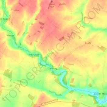
Название: Топографическая карта Bibury, высота, рельеф.
Местонахождение: Bibury, Cotswold District, Gloucestershire, England, United Kingdom (51.73942 -1.86928 51.79538 -1.78876)
Средняя высота: 135 м
Минимальная высота: 94 м
Максимальная высота: 163 м
The parish is approximately rectangular and stretches far to the rolling, elevated, north. It includes on outlying settlement, Ablington, in the upper valley. Bibury Farm is 300 metres (330 yd) from the village, 151 metres (495 ft) above Ordnance Datum (AOD), which is a similar elevation to much of the north. The south rises to a maximum of 141 metres (463 ft) on its periphery along Akeman Street, a Roman road, before ascending further in other more distant lands. The valley floor within the Bibury boundary, northwest and southeast, ranges from 108 to 98 metres (354 to 322 ft) AOD.
Другие топографические карты
Нажмите на карту, чтобы просмотреть ее топографию, ее высоту и ее рельеф.
![Топографическая карта Baunton, высота, рельеф](/pub/maps/relation/xp5k/p6vbcz/icon.jpg)
Baunton
United Kingdom > England > Gloucestershire > Cotswold District > Baunton
Baunton, Cotswold District, Gloucestershire, England, United Kingdom
Средняя высота: 146 м
![Топографическая карта Condicote, высота, рельеф](/pub/maps/node/z6t6/2nvb85k/icon.jpg)
Condicote
United Kingdom > England > Gloucestershire > Cotswold District
Condicote, Cotswold District, Gloucestershire, England, GL54 1ES, United Kingdom
Средняя высота: 201 м
![Топографическая карта Lower Slaughter, высота, рельеф](/pub/maps/node/qgt/kg7z2gt/icon.jpg)
Lower Slaughter
United Kingdom > England > Gloucestershire > Cotswold District
Lower Slaughter, Cotswold District, Gloucestershire, England, GL54 2HX, United Kingdom
Средняя высота: 160 м
![Топографическая карта Cutsdean, высота, рельеф](/pub/maps/relation/hhm2/c4t3nx/icon.jpg)
Cutsdean
United Kingdom > England > Gloucestershire > Cotswold District
Cutsdean, Cotswold District, Gloucestershire, England, United Kingdom
Средняя высота: 233 м
![Топографическая карта Dowdeswell, высота, рельеф](/pub/maps/relation/3v1h/7jh18/icon.jpg)
Dowdeswell
United Kingdom > England > Gloucestershire > Cotswold District
Dowdeswell, Cotswold District, Gloucestershire, England, United Kingdom
Средняя высота: 209 м
![Топографическая карта Daylesford, высота, рельеф](/pub/maps/node/34dn/8ctc49m/icon.jpg)
Daylesford
United Kingdom > England > Gloucestershire > Cotswold District
Daylesford, Cotswold District, Gloucestershire, England, GL56 0YG, United Kingdom
Средняя высота: 137 м
![Топографическая карта Barnsley, высота, рельеф](/pub/maps/node/sns8/qqrx5tf/icon.jpg)
Barnsley
United Kingdom > England > Gloucestershire > Cotswold District
Barnsley, Cotswold District, Gloucestershire, England, GL7 5EF, United Kingdom
Средняя высота: 135 м
![Топографическая карта Maugersbury, высота, рельеф](/pub/maps/node/hldn/75j47gt/icon.jpg)
Maugersbury
United Kingdom > England > Gloucestershire > Cotswold District
Maugersbury, Cotswold District, Gloucestershire, England, GL54 1HR, United Kingdom
Средняя высота: 166 м
![Топографическая карта Duntisbourne Abbots, высота, рельеф](/pub/maps/node/6bmt/sbn3g3q/icon.jpg)
Duntisbourne Abbots
United Kingdom > England > Gloucestershire > Cotswold District
Duntisbourne Abbots, Cotswold District, Gloucestershire, England, GL7 7JN, United Kingdom
Средняя высота: 204 м
![Топографическая карта Tarlton, высота, рельеф](/pub/maps/node/7518/gnfrjnh/icon.jpg)
Tarlton
United Kingdom > England > Gloucestershire > Cotswold District
Tarlton, Rodmarton, Cotswold District, Gloucestershire, England, GL7 6PA, United Kingdom
Средняя высота: 144 м
![Топографическая карта Bagpath, высота, рельеф](/pub/maps/node/xhf3/cmx8scz/icon.jpg)
Bagpath
United Kingdom > England > Gloucestershire > Cotswold District
Bagpath, Kingscote, Cotswold District, Gloucestershire, England, GL8 8YG, United Kingdom
Средняя высота: 198 м
![Топографическая карта Cerney Wick, высота, рельеф](/pub/maps/node/31dn/pl8nrkl/icon.jpg)
Cerney Wick
United Kingdom > England > Gloucestershire > Cotswold District
Cerney Wick, Cotswold District, Gloucestershire, England, GL7 5QH, United Kingdom
Средняя высота: 85 м
![Топографическая карта Birdlip, высота, рельеф](/pub/maps/relation/p7cz/vbnts8/icon.jpg)
Birdlip
United Kingdom > England > Gloucestershire > Cotswold District
Birdlip, Cotswold District, Gloucestershire, England, United Kingdom
Средняя высота: 261 м
![Топографическая карта Worcestershire (detached), высота, рельеф](/pub/maps/relation/klzs/vndhnx/icon.jpg)
Worcestershire (detached)
United Kingdom > England > Gloucestershire > Cotswold District
Worcestershire (detached), Cotswold District, Gloucestershire, West Midlands Combined Authority, England, United Kingdom
Средняя высота: 103 м
![Топографическая карта Cirencester, высота, рельеф](/pub/maps/relation/z85k/fbsdgp/icon.jpg)
Cirencester
United Kingdom > England > Gloucestershire > Cotswold District > Chesterton
Cirencester, Chesterton, Cotswold District, Gloucestershire, England, United Kingdom
Средняя высота: 128 м
![Топографическая карта Syde, высота, рельеф](/pub/maps/node/ck3q/bq5l2b3/icon.jpg)
Syde
United Kingdom > England > Gloucestershire > Cotswold District
Syde, Cotswold District, Gloucestershire, England, GL53 9PN, United Kingdom
Средняя высота: 238 м
![Топографическая карта Taylors Hill, высота, рельеф](/pub/maps/node/wpnx/6n6g8tj/icon.jpg)
Taylors Hill
United Kingdom > England > Gloucestershire > Cotswold District
Taylors Hill, Cotswold District, Gloucestershire, England, GL54 4BJ, United Kingdom
Средняя высота: 237 м
![Топографическая карта Mickleton, высота, рельеф](/pub/maps/node/kcb3/jhbsfdn/icon.jpg)
Mickleton
United Kingdom > England > Gloucestershire > Cotswold District
Mickleton, Cotswold District, Gloucestershire, England, GL55 6TS, United Kingdom
Средняя высота: 101 м
![Топографическая карта Trewsbury Mead, высота, рельеф](/pub/maps/node/t8m2/sgmnl6cz/icon.jpg)
Trewsbury Mead
United Kingdom > England > Gloucestershire > Cotswold District
Trewsbury Mead, Coates, Cotswold District, Gloucestershire, England, GL7 6NY, United Kingdom
Средняя высота: 122 м
![Топографическая карта North Cerney, высота, рельеф](/pub/maps/node/14m2/3r3g93q/icon.jpg)
North Cerney
United Kingdom > England > Gloucestershire > Cotswold District
North Cerney, Cotswold District, Gloucestershire, England, GL7 7BZ, United Kingdom
Средняя высота: 179 м
![Топографическая карта Hatherop, высота, рельеф](/pub/maps/node/3ndn/m84hb3q/icon.jpg)
Hatherop
United Kingdom > England > Gloucestershire > Cotswold District
Hatherop, Cotswold District, Gloucestershire, England, GL7 3NA, United Kingdom
Средняя высота: 120 м
![Топографическая карта Stow-on-the-Wold, высота, рельеф](/pub/maps/node/4wrr/h14l57/icon.jpg)
Stow-on-the-Wold
United Kingdom > England > Gloucestershire > Cotswold District
Stow-on-the-Wold, Cotswold District, Gloucestershire, England, GL54 1AB, United Kingdom
Средняя высота: 163 м
![Топографическая карта Botany Bay Wood, высота, рельеф](/pub/maps/way/kz1h/6thkpgp/icon.jpg)
Botany Bay Wood
United Kingdom > England > Gloucestershire > Cotswold District > Stow-on-the-Wold
Botany Bay Wood, Maugersbury, Stow-on-the-Wold, Cotswold District, Gloucestershire, England, United Kingdom
Средняя высота: 171 м
![Топографическая карта Eastleach Martin, высота, рельеф](/pub/maps/node/mzdn/vvg24prr/icon.jpg)
Eastleach Martin
United Kingdom > England > Gloucestershire > Cotswold District > Eastleach Turville
Eastleach Martin, Eastleach, Eastleach Turville, Cotswold District, Gloucestershire, England, GL7 3NW, United Kingdom
Средняя высота: 111 м
![Топографическая карта Chipping Campden, высота, рельеф](/pub/maps/relation/4jdn/fb9sgp/icon.jpg)
Chipping Campden
United Kingdom > England > Gloucestershire > Cotswold District
Chipping Campden, Cotswold District, Gloucestershire, England, United Kingdom
Средняя высота: 191 м
![Топографическая карта Saintbury, высота, рельеф](/pub/maps/node/glkl/sgn4j5k/icon.jpg)
Saintbury
United Kingdom > England > Gloucestershire > Cotswold District
Saintbury, Cotswold District, Gloucestershire, England, WR12 7PX, United Kingdom
Средняя высота: 124 м
![Топографическая карта Coberley, высота, рельеф](/pub/maps/node/7bkl/w44tfmt/icon.jpg)
Coberley
United Kingdom > England > Gloucestershire > Cotswold District
Coberley, Cotswold District, Gloucestershire, England, GL53 9QZ, United Kingdom
Средняя высота: 240 м
![Топографическая карта Somerford Keynes, высота, рельеф](/pub/maps/node/mnmt/9vvn8dn/icon.jpg)
Somerford Keynes
United Kingdom > England > Gloucestershire > Cotswold District
Somerford Keynes, Cotswold District, Gloucestershire, England, GL7 6DR, United Kingdom
Средняя высота: 91 м
![Топографическая карта Lechlade, высота, рельеф](/pub/maps/node/k1f3/366bnx/icon.jpg)
Lechlade
United Kingdom > England > Gloucestershire > Cotswold District
Lechlade, Cotswold District, Gloucestershire, England, GL7 3BY, United Kingdom
Средняя высота: 81 м
![Топографическая карта Naunton, высота, рельеф](/pub/maps/node/7914/jbxj2kl/icon.jpg)
Naunton
United Kingdom > England > Gloucestershire > Cotswold District
Naunton, Cotswold District, Gloucestershire, England, GL54 3AS, United Kingdom
Средняя высота: 201 м
![Топографическая карта Knap House Quarry, Birdlip, высота, рельеф](/pub/maps/way/f4s8/szd6srb3/icon.jpg)
Knap House Quarry, Birdlip
United Kingdom > England > Gloucestershire > Cotswold District > Birdlip
Knap House Quarry, Birdlip, Cowley, Birdlip, Cotswold District, Gloucestershire, England, United Kingdom
Средняя высота: 222 м
![Топографическая карта South Cerney, высота, рельеф](/pub/maps/relation/t8tj/db2s1h/icon.jpg)
South Cerney
United Kingdom > England > Gloucestershire > Cotswold District > South Cerney
South Cerney, Cotswold District, Gloucestershire, England, United Kingdom
Средняя высота: 93 м
![Топографическая карта Withington, высота, рельеф](/pub/maps/relation/623l/8x4z51/icon.jpg)
Withington
United Kingdom > England > Gloucestershire > Cotswold District
Withington, Cotswold District, Gloucestershire, England, United Kingdom
Средняя высота: 212 м
![Топографическая карта Down Ampney, высота, рельеф](/pub/maps/node/49cz/9xb1snh/icon.jpg)
Down Ampney
United Kingdom > England > Gloucestershire > Cotswold District
Down Ampney, Cotswold District, Gloucestershire, England, GL7 5QR, United Kingdom
Средняя высота: 85 м
![Топографическая карта Weston-sub-Edge, высота, рельеф](/pub/maps/node/d18/4f4p8nh/icon.jpg)
Weston-sub-Edge
United Kingdom > England > Gloucestershire > Cotswold District
Weston-sub-Edge, Cotswold District, Gloucestershire, England, GL55 6QZ, United Kingdom
Средняя высота: 98 м
![Топографическая карта Compton Abdale, высота, рельеф](/pub/maps/node/97t6/gg4jxs8/icon.jpg)
Compton Abdale
United Kingdom > England > Gloucestershire > Cotswold District
Compton Abdale, Cotswold District, Gloucestershire, England, GL54 4DS, United Kingdom
Средняя высота: 212 м
![Топографическая карта Broad Campden, высота, рельеф](/pub/maps/node/4d3q/wjxrnz4/icon.jpg)
Broad Campden
United Kingdom > England > Gloucestershire > Cotswold District
Broad Campden, Cotswold District, Gloucestershire, England, GL55 6UU, United Kingdom
Средняя высота: 167 м
![Топографическая карта Tetbury, высота, рельеф](/pub/maps/relation/g1t6/lwjsmt/icon.jpg)
Tetbury
United Kingdom > England > Gloucestershire > Cotswold District
Tetbury, Cotswold District, Gloucestershire, England, United Kingdom
Средняя высота: 122 м
![Топографическая карта Upper Oddington, высота, рельеф](/pub/maps/node/mmdn/l22z2zs/icon.jpg)
Upper Oddington
United Kingdom > England > Gloucestershire > Cotswold District
Upper Oddington, Cotswold District, Gloucestershire, England, GL56 0XH, United Kingdom
Средняя высота: 134 м
![Топографическая карта Paxford, высота, рельеф](/pub/maps/node/6mb3/bzpr2s8/icon.jpg)
Paxford
United Kingdom > England > Gloucestershire > Cotswold District > Paxford
Paxford, Cotswold District, Gloucestershire, England, GL55 6XW, United Kingdom
Средняя высота: 124 м
![Топографическая карта Winstone, высота, рельеф](/pub/maps/node/7m4s/w7q3q3q/icon.jpg)
Winstone
United Kingdom > England > Gloucestershire > Cotswold District > Winstone
Winstone, Cotswold District, Gloucestershire, England, GL7 7JX, United Kingdom
Средняя высота: 222 м
![Топографическая карта Ampney Crucis, высота, рельеф](/pub/maps/node/g5zs/j1qcvzs/icon.jpg)
Ampney Crucis
United Kingdom > England > Gloucestershire > Cotswold District
Ampney Crucis, Cotswold District, Gloucestershire, England, GL7 5SD, United Kingdom
Средняя высота: 114 м
![Топографическая карта Moreton-in-Marsh, высота, рельеф](/pub/maps/relation/5rnx/5nc8t6/icon.jpg)
Moreton-in-Marsh
United Kingdom > England > Gloucestershire > Cotswold District
Moreton-in-Marsh, Cotswold District, Gloucestershire, England, United Kingdom
Средняя высота: 135 м
![Топографическая карта Shorncote, высота, рельеф](/pub/maps/node/8dtp/9v1x5dn/icon.jpg)
Shorncote
United Kingdom > England > Gloucestershire > Cotswold District
Shorncote, Somerford Keynes, Cotswold District, Gloucestershire, England, GL7 6DE, United Kingdom
Средняя высота: 96 м
![Топографическая карта Northleach, высота, рельеф](/pub/maps/node/51tf/k9g24gp/icon.jpg)
Northleach
United Kingdom > England > Gloucestershire > Cotswold District
Northleach, Cotswold District, Gloucestershire, England, GL54 3EE, United Kingdom
Средняя высота: 179 м
![Топографическая карта Aldsworth, высота, рельеф](/pub/maps/node/gvnx/kg4t8gt/icon.jpg)
Aldsworth
United Kingdom > England > Gloucestershire > Cotswold District
Aldsworth, Cotswold District, Gloucestershire, England, GL54 3QX, United Kingdom
Средняя высота: 142 м
![Топографическая карта Bledington, высота, рельеф](/pub/maps/node/gwtf/l71bnrr/icon.jpg)
Bledington
United Kingdom > England > Gloucestershire > Cotswold District > Bledington
Bledington, Cotswold District, Gloucestershire, South West England, England, OX7 6XQ, United Kingdom
Средняя высота: 118 м
![Топографическая карта Fairford, высота, рельеф](/pub/maps/relation/8ptp/nljftj/icon.jpg)
Fairford
United Kingdom > England > Gloucestershire > Cotswold District
Fairford, Cotswold District, Gloucestershire, England, United Kingdom
Средняя высота: 98 м
![Топографическая карта Ablington, высота, рельеф](/pub/maps/node/cn57/5gmtrzs/icon.jpg)
Ablington
United Kingdom > England > Gloucestershire > Cotswold District > Ablington
Ablington, Cotswold District, Gloucestershire, South West England, England, GL7 5NY, United Kingdom
Средняя высота: 136 м
![Топографическая карта Meysey Hampton, высота, рельеф](/pub/maps/node/6jtp/9xb131h/icon.jpg)
Meysey Hampton
United Kingdom > England > Gloucestershire > Cotswold District > Meysey Hampton
Meysey Hampton, Cotswold District, Gloucestershire, South West England, England, GL7 5JT, United Kingdom
Средняя высота: 96 м