
Сделать пожертвование
Топографическая карта Chiloquin
Нажмите на карту, чтобы отобразить высоту.
Сделать пожертвование
Chiloquin
Chiloquin is at an elevation of 4,180 feet (1,270 m) in Klamath County. The city is slightly east of U.S. Route 97 and slightly north of its intersection with Oregon Route 62. A short east–west highway, Oregon Route 422, links Route 97 at Chiloquin to Route 62 slightly south of Klamath Agency. By highway, Chiloquin is about 26 miles (42 km) north of Klamath Falls and 253 miles (407 km) south of Portland.
Сделать пожертвование
Об этой карте
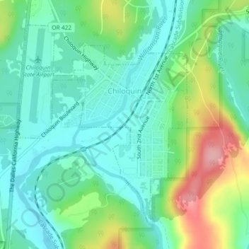
Название: Топографическая карта Chiloquin, высота, рельеф.
Местонахождение: Chiloquin, Klamath County, Oregon, United States (42.56307 -121.88208 42.58478 -121.85693)
Средняя высота: 1 302 м
Минимальная высота: 1 262 м
Максимальная высота: 1 395 м
Сделать пожертвование
Другие топографические карты
Нажмите на карту, чтобы просмотреть ее топографию, ее высоту и ее рельеф.
Сделать пожертвование
Lake of the Woods
United States > Oregon > Klamath County
Lake of the Woods is located near the crest of the Cascade Mountains in western Klamath County, Oregon. Its elevation is 4,949 feet (1,508 m) above sea level. The lake is surrounded by the Fremont–Winema National Forest. Lake of the Woods is 33 miles (53 km) west of Klamath Falls and 43 miles (69 km) east of…
Средняя высота: 1 588 м
Mount Mazama
United States > Oregon > Klamath County
Mount Mazama (Tum-sum-ne in the Native American language Klamath) is a complex volcano in the western U.S. state of Oregon, in a segment of the Cascade Volcanic Arc and Cascade Range. The volcano is in Klamath County, in the southern Cascades, 60 miles (97 km) north of the Oregon–California border. Its…
Средняя высота: 1 880 м
Сделать пожертвование
Mount Scott
United States > Oregon > Klamath County
There is one trail to the summit of Mount Scott. Starting on Rim Drive, the trail is about 2.5 miles (4.0 km) long. It has many switchbacks, and ends at the fire lookout tower on the summit. The trailhead is at an elevation of 7,683 feet (2,342 m), and the trail climbs approximately 1,479 feet (451 m) to the…
Средняя высота: 2 295 м
Сделать пожертвование