
Топографическая карта Lake of the Woods
Интерактивная карта
Нажмите на карту, чтобы отобразить высоту.
Об этой карте
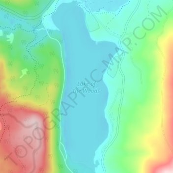
Название: Топографическая карта Lake of the Woods, высота, рельеф.
Местонахождение: Lake of the Woods, Klamath County, Oregon, United States (42.34352 -122.22695 42.38850 -122.20306)
Средняя высота: 1 588 м
Минимальная высота: 1 501 м
Максимальная высота: 1 798 м
Lake of the Woods is located near the crest of the Cascade Mountains in western Klamath County, Oregon. Its elevation is 4,949 feet (1,508 m) above sea level. The lake is surrounded by the Fremont–Winema National Forest. Lake of the Woods is 33 miles (53 km) west of Klamath Falls and 43 miles (69 km) east of Medford. The small unincorporated community of Lake of the Woods, Oregon, is located on the east shore of the lake, approximately 1⁄2 mile (0.80 km) south of Oregon Route 140. There is a Forest Service visitor center at the historic Lake of the Woods Ranger Station at the north end of the lake, just off Route 140. The visitor center is open during the summer.
Другие топографические карты
Нажмите на карту, чтобы просмотреть ее топографию, ее высоту и ее рельеф.
Klamath Falls
United States > Oregon > Klamath County
Klamath Falls, Klamath County, Oregon, 97601, United States
Средняя высота: 1 312 м
Saddle Mountain
United States > Oregon > Klamath County
Saddle Mountain, Klamath County, Oregon, United States
Средняя высота: 1 758 м
Dairy
United States > Oregon > Klamath County
Dairy, Klamath County, Oregon, 97625, United States
Средняя высота: 1 300 м
Crater Lake National Park
United States > Oregon > Klamath County
Crater Lake National Park, Klamath County, Oregon, 97604, United States
Средняя высота: 1 726 м
Rock Point
United States > Oregon > Klamath County
Rock Point, Klamath County, Oregon, 97731, United States
Средняя высота: 1 415 м
Altamont
United States > Oregon > Klamath County
Altamont, Klamath County, Oregon, 97603, United States
Средняя высота: 1 310 м
Chemult
United States > Oregon > Klamath County
Chemult, Klamath County, Oregon, United States
Средняя высота: 1 480 м
Crescent
United States > Oregon > Klamath County
Crescent, Klamath County, Oregon, United States
Средняя высота: 1 389 м
Sprague River
United States > Oregon > Klamath County
Sprague River, Klamath County, Oregon, 97639, United States
Средняя высота: 1 472 м
Malin
United States > Oregon > Klamath County
Malin, Klamath County, Oregon, United States
Средняя высота: 1 241 м
Altamont
United States > Oregon > Klamath County > Altamont
Altamont, Klamath County, Oregon, 97603, United States
Средняя высота: 1 285 м
Merrill
United States > Oregon > Klamath County
Merrill, Klamath County, Oregon, United States
Средняя высота: 1 241 м
Mount Scott
United States > Oregon > Klamath County
Mount Scott, Klamath County, Oregon, United States
Средняя высота: 2 295 м
Fort Klamath
United States > Oregon > Klamath County
Fort Klamath, Klamath County, Oregon, United States
Средняя высота: 1 273 м
Chiloquin
United States > Oregon > Klamath County
Chiloquin, Klamath County, Oregon, United States
Средняя высота: 1 302 м
Beatty
United States > Oregon > Klamath County
Beatty, Klamath County, Oregon, 97602, United States
Средняя высота: 1 330 м
Odell Lake
United States > Oregon > Klamath County > Odell Lake
Odell Lake, Klamath County, Oregon, United States
Средняя высота: 1 492 м
Crater Lake
United States > Oregon > Klamath County
Crater Lake, Klamath County, Oregon, United States
Средняя высота: 1 971 м
Bonanza
United States > Oregon > Klamath County
Bonanza, Klamath County, Oregon, United States
Средняя высота: 1 263 м
Keno
United States > Oregon > Klamath County
Keno, Klamath County, Oregon, 97627, United States
Средняя высота: 1 287 м
Mount Mazama
United States > Oregon > Klamath County
Mount Mazama, Klamath County, Oregon, United States
Средняя высота: 1 880 м