
Сделать пожертвование
Топографическая карта Shangqiu
Нажмите на карту, чтобы отобразить высоту.
Сделать пожертвование
Shangqiu
Shangqiu is the easternmost prefecture of Henan province. Its administrative area ranges in longitude from 114 °49′ E to 116° 39′ E and in latitude from 33° 43′ N to 34° 52′ N, covering 10,704 square kilometres (4,133 sq mi). The city lies on the North China Plain and is mostly flat, with elevations ranging from 30 to 70 metres (98 to 230 ft), though the northwest part of the prefecture is more elevated than the southeast.
Сделать пожертвование
Об этой карте
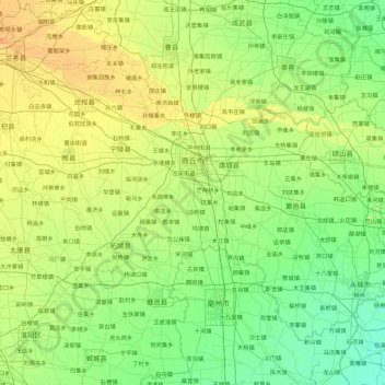
Название: Топографическая карта Shangqiu, высота, рельеф.
Местонахождение: Shangqiu, Henan, China (33.70752 114.82244 34.86343 116.64562)
Средняя высота: 47 м
Минимальная высота: 28 м
Максимальная высота: 118 м
Сделать пожертвование
Другие топографические карты
Нажмите на карту, чтобы просмотреть ее топографию, ее высоту и ее рельеф.
Сделать пожертвование
Сделать пожертвование
Сделать пожертвование
Сделать пожертвование
Anyang
Anyang spans a total area of 7,355 square kilometres (2,840 sq mi). The city's elevation is generally higher in the west, with the foothills of the Taihang Mountains running through the area, and lower in the east, which comprises part of the North China Plain.
Средняя высота: 102 м
Сделать пожертвование