
Сделать пожертвование
Топографическая карта Anyang
Нажмите на карту, чтобы отобразить высоту.
Сделать пожертвование
Anyang
Anyang spans a total area of 7,355 square kilometres (2,840 sq mi). The city's elevation is generally higher in the west, with the foothills of the Taihang Mountains running through the area, and lower in the east, which comprises part of the North China Plain.
Сделать пожертвование
Об этой карте
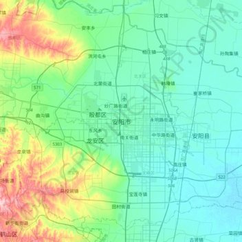
Название: Топографическая карта Anyang, высота, рельеф.
Местонахождение: Anyang, Beiguan District, Anyang City, Henan, China (35.94236 114.17633 36.26236 114.49633)
Средняя высота: 102 м
Минимальная высота: 56 м
Максимальная высота: 275 м
Сделать пожертвование
Другие топографические карты
Нажмите на карту, чтобы просмотреть ее топографию, ее высоту и ее рельеф.
Сделать пожертвование
Сделать пожертвование
Сделать пожертвование
Сделать пожертвование
Xichuan County
Xichuan is located south of Funiu Mountain. The county is about 107 kilometers from northwest to southeast, with a width of 46 kilometers and a total area of 2,798 square kilometers. Xichuan County is a horseshoe-shaped terrain that protrudes to the southeast in the northwest direction. The northwest is a low…
Средняя высота: 319 м
Сделать пожертвование
Сделать пожертвование
Сделать пожертвование
Сделать пожертвование
Guancheng Hui District
Guancheng Hui District has an elevation ranging from about 100 metres (330 ft) to 140 metres (460 ft) above sea level.
Средняя высота: 112 м
Сделать пожертвование
Сделать пожертвование
Сделать пожертвование
Сделать пожертвование
Yongcheng City
Yongcheng is located in the Huai River Basin, in the easternmost part of Henan Province, with an average elevation of 33 meters. The Tuo hui River passes through the northern part of the western urban area and the southern part of the eastern urban area. The Mang Mountain is located in the northern Mangshan…
Средняя высота: 37 м
Сделать пожертвование
Сделать пожертвование
Сделать пожертвование
Сделать пожертвование
Shangqiu
Shangqiu is the easternmost prefecture of Henan province. Its administrative area ranges in longitude from 114 °49′ E to 116° 39′ E and in latitude from 33° 43′ N to 34° 52′ N, covering 10,704 square kilometres (4,133 sq mi). The city lies on the North China Plain and is mostly flat, with…
Средняя высота: 47 м
Сделать пожертвование