
Сделать пожертвование
Топографическая карта Lago Norte
Нажмите на карту, чтобы отобразить высоту.
Сделать пожертвование
Об этой карте
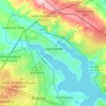
Название: Топографическая карта Lago Norte, высота, рельеф.
Средняя высота: 1 077 м
Минимальная высота: 997 м
Максимальная высота: 1 254 м
Сделать пожертвование
Другие топографические карты
Нажмите на карту, чтобы просмотреть ее топографию, ее высоту и ее рельеф.
Brasília
Brazil > Federal District > Região Integrada de Desenvolvimento do Distrito Federal e Entorno
The city sits at an elevation of 1,000 metres (3,300 ft) and more, high on the Brazilian Highlands in the country's center-western region. Paranoá Lake, a large artificial lake, was built to increase the amount of water available and to maintain the region's humidity. It has a marina, and hosts wakeboarders…
Средняя высота: 1 084 м
Condominio Verde Perto
Brazil > Federal District > Região Integrada de Desenvolvimento do Distrito Federal e Entorno > Guará
Средняя высота: 1 099 м