
Сделать пожертвование
Топографическая карта Brasília
Нажмите на карту, чтобы отобразить высоту.
Сделать пожертвование
Brasília
The city sits at an elevation of 1,000 metres (3,300 ft) and more, high on the Brazilian Highlands in the country's center-western region. Paranoá Lake, a large artificial lake, was built to increase the amount of water available and to maintain the region's humidity. It has a marina, and hosts wakeboarders and windsurfers. Diving can also be practiced and one of the main attractions is Vila Amaury, an old village submerged in the lake. This is where the first construction workers of Brasilia used to live.
Сделать пожертвование
Об этой карте
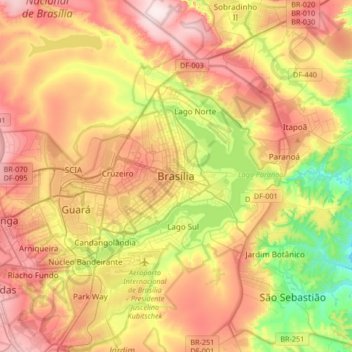
Название: Топографическая карта Brasília, высота, рельеф.
Средняя высота: 1 084 м
Минимальная высота: 865 м
Максимальная высота: 1 304 м
Сделать пожертвование
Другие топографические карты
Нажмите на карту, чтобы просмотреть ее топографию, ее высоту и ее рельеф.
Lago Sul
Brazil > Federal District > Região Integrada de Desenvolvimento do Distrito Federal e Entorno
Средняя высота: 1 076 м
SIA
Brazil > Federal District > Região Integrada de Desenvolvimento do Distrito Federal e Entorno
Средняя высота: 1 108 м
Vicente Pires
Brazil > Federal District > Região Integrada de Desenvolvimento do Distrito Federal e Entorno
Средняя высота: 1 123 м
Guará
Brazil > Federal District > Região Integrada de Desenvolvimento do Distrito Federal e Entorno
Средняя высота: 1 087 м
Сделать пожертвование
Sobradinho II
Brazil > Federal District > Região Integrada de Desenvolvimento do Distrito Federal e Entorno
Средняя высота: 986 м
Lago Norte
Brazil > Federal District > Região Integrada de Desenvolvimento do Distrito Federal e Entorno
Средняя высота: 1 077 м
Taguatinga
Brazil > Federal District > Região Integrada de Desenvolvimento do Distrito Federal e Entorno
Средняя высота: 1 181 м
Jardim Botânico
Brazil > Federal District > Região Integrada de Desenvolvimento do Distrito Federal e Entorno
Средняя высота: 1 024 м
Сделать пожертвование
Lago Sul
Brazil > Federal District > Região Integrada de Desenvolvimento do Distrito Federal e Entorno
Средняя высота: 1 076 м
Ceilândia
Brazil > Federal District > Região Integrada de Desenvolvimento do Distrito Federal e Entorno
Средняя высота: 1 143 м