
Сделать пожертвование
Топографическая карта Kyneton
Нажмите на карту, чтобы отобразить высоту.
Сделать пожертвование
Об этой карте
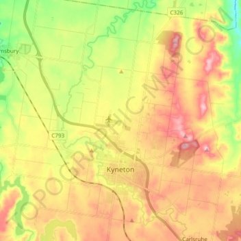
Название: Топографическая карта Kyneton, высота, рельеф.
Местонахождение: Kyneton, Victoria, 3444, Australia (-37.27517 144.38396 -37.17144 144.53371)
Средняя высота: 504 м
Минимальная высота: 393 м
Максимальная высота: 611 м
Сделать пожертвование
Другие топографические карты
Нажмите на карту, чтобы просмотреть ее топографию, ее высоту и ее рельеф.
Ballarat
Ballarat has a moderate oceanic climate (Köppen climate classification Cfb) with four distinct seasons. Its elevation, ranging between 400 and 630 metres (1,310 and 2,070 feet) above sea level, causes its mean monthly temperatures to tend to be on average 3 to 5 °C (5 to 9 °F) below those of Melbourne,…
Средняя высота: 470 м
Yarra Valley
Australia > Victoria > Melbourne
The Yarra Valley is the region surrounding the Yarra River in Victoria, Australia. The river originates approximately 240 km (150 mi) east of the Melbourne central business district and flows towards it and out into Port Phillip Bay. The name Yarra Valley is used in reference to the upper regions surrounding…
Средняя высота: 305 м
Сделать пожертвование
Melbourne
Melbourne is also prone to isolated convective showers forming when a cold pool crosses the state, especially if there is considerable daytime heating. These showers are often heavy and can include hail, squalls, and significant drops in temperature, but they often pass through very quickly with a rapid…
Средняя высота: 49 м
Сделать пожертвование
Сделать пожертвование
Mount Napier
Mount Napier, or Tapoc in the local Aboriginal language, has a composite lava shield with a superimposed scoria cone. The cone rises 150 metres (490 ft) above the surrounding plains to an elevation of 440 metres (1,440 ft), making it the highest point on the Western District Plains of Victoria. Mount Napier is…
Средняя высота: 266 м
Сделать пожертвование
Сделать пожертвование
Сделать пожертвование
Сделать пожертвование
Сделать пожертвование
Ballarat
Ballarat has a moderate oceanic climate (Köppen climate classification Cfb) with four distinct seasons. Its elevation, ranging between 400 and 630 metres (1,310 and 2,070 feet) above sea level, causes its mean monthly temperatures to tend to be on average 3 to 5 °C (5 to 9 °F) below those of Melbourne,…
Средняя высота: 470 м
Сделать пожертвование
Сделать пожертвование
Сделать пожертвование
Сделать пожертвование
Сделать пожертвование
Сделать пожертвование
Сделать пожертвование
Сделать пожертвование
Сделать пожертвование
Сделать пожертвование
Mount Bogong
The Big River separates the massif of the mountain from the Bogong High Plains to the south. From the nearby town of Mount Beauty to its summit, Mount Bogong rises more than 1,600 metres (5,200 ft), thus making it one of the highest peaks in Australia not only in terms of its elevation above sea level, but…
Средняя высота: 1 719 м
Сделать пожертвование
Сделать пожертвование
Сделать пожертвование
Сделать пожертвование
Buffalo Plateau
The summit of the highest peak of the plateau, known as The Horn, has an elevation of 1,723 metres (5,653 ft) AHD.
Средняя высота: 1 502 м
Сделать пожертвование
Сделать пожертвование
Сделать пожертвование