
Сделать пожертвование
Топографическая карта Geelong
Нажмите на карту, чтобы отобразить высоту.
Сделать пожертвование
Об этой карте
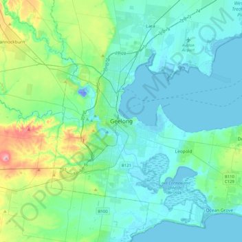
Название: Топографическая карта Geelong, высота, рельеф.
Местонахождение: Geelong, City of Greater Geelong, Victoria, 3220, Australia (-38.30932 144.19982 -37.98932 144.51982)
Средняя высота: 42 м
Минимальная высота: -28 м
Максимальная высота: 260 м
Сделать пожертвование
Другие топографические карты
Нажмите на карту, чтобы просмотреть ее топографию, ее высоту и ее рельеф.
City of Melbourne
Melbourne's topography is characterized by a diverse landscape that transitions from flat coastal plains to rolling hills and mountainous regions. The city is situated at the northern end of Port Phillip Bay, where the terrain is predominantly flat, facilitating urban development. As one moves eastward, the…
Средняя высота: 18 м
Melbourne
Melbourne is also prone to isolated convective showers forming when a cold pool crosses the state, especially if there is considerable daytime heating. These showers are often heavy and can include hail, squalls, and significant drops in temperature, but they often pass through very quickly with a rapid…
Средняя высота: 185 м
Сделать пожертвование
Сделать пожертвование
Grampians National Park
Mount William is known within the gliding community for the "Grampians Wave", a weather phenomenon that sometimes enables glider pilots to reach extreme altitudes of the order of 28,000 ft (8,500 m). This predominantly occurs during the months of May, June, September and October when strong westerly winds flow…
Средняя высота: 262 м
Omeo
There are bus routes from Bright and Bairnsdale. The Bairnsdale bus runs weekdays, once both directions, and the Bright bus (Alps Link) timetable is less frequent in Summer and runs additional services during the ski season. Alps Link is the highest altitude public bus in Australia. The town sits at the…
Средняя высота: 861 м
Сделать пожертвование
Сделать пожертвование
Beaufort
Beaufort has an elevation-influenced oceanic climate (Köppen: Cfb), with tepid, relatively dry summers and cool, wetter winters. Average maxima vary from 25.3 °C (77.5 °F) in January to 10.1 °C (50.2 °F) in July, while average minima fluctuate between 11.5 °C (52.7 °F) in February and 3.2 °C (37.8 °F)…
Средняя высота: 390 м
Сделать пожертвование
Сделать пожертвование
Simpson
Simpson is part of one of the most productive dairying centres in Australia. Dairying has become a major activity in the area and a significant contributor to the State’s dairying industry. The region consists of dissected plains exposing a range of land types with different topography, lithology and soils.…
Средняя высота: 120 м
Port Phillip
Port Phillip's mostly flat topography and moderate waves make perfect conditions for recreational swimming, kitesurfing, windsurfing, sailing, boating, snorkeling, scuba diving, stand up paddle boarding (SUP) and other sports.
Средняя высота: 18 м
Сделать пожертвование
Сделать пожертвование
Mount Dandenong
Australia > Victoria > Melbourne
Mount Dandenong has an oceanic climate (Cfb) with warm summers and cool winters. The temperature usually is 3 - 7 °C (5.4 - 12.6 °F) cooler than downtown Melbourne due to its elevation and distance from the urban island heating effect of Melbourne.
Средняя высота: 408 м
Сделать пожертвование
Сделать пожертвование
Сделать пожертвование
Melbourne
Melbourne is also prone to isolated convective showers forming when a cold pool crosses the state, especially if there is considerable daytime heating. These showers are often heavy and can include hail, squalls, and significant drops in temperature, but they often pass through very quickly with a rapid…
Средняя высота: 185 м
Сделать пожертвование
Trentham
Trentham is a small town in the Shire of Hepburn and Shire of Moorabool local government area, Victoria, Australia. At the 2016 census, Trentham had a population of 1,180, with a median age of 55 years. Located at an altitude of 700 metres (2,297 ft), the town is 87 kilometres (54 mi) north-west of Melbourne.
Средняя высота: 702 м
Сделать пожертвование
Сделать пожертвование
Сделать пожертвование
Western Port
Formerly a major river drainage system, it was inundated together with Port Phillip by the rising sea in the Holocene period; the Western Port sunkland now forms an extensive tidal bay. The waters of Western Port cover an area of 680 km² of which 270 km² are exposed as mud flats at low tide. The topography…
Средняя высота: 35 м
Сделать пожертвование
Сделать пожертвование
Сделать пожертвование
Сделать пожертвование
Сделать пожертвование
Сделать пожертвование
Сделать пожертвование
Сделать пожертвование
Сделать пожертвование
Сделать пожертвование