
Сделать пожертвование
Топографическая карта Aquila
Нажмите на карту, чтобы отобразить высоту.
Сделать пожертвование
Aquila
Aquila (Spanish pronunciation: [aˈkila]) is a town in the southwest part of the Mexican state of Michoacán. It is the municipal seat for the municipality of Aquila. It is 23 mi/43 km southeast of Tecoman. Its population was 1,915 in 2002. It is located at Latitude: 18°35'N Longitude: 103°31'W and at elevation 989 ft/510 m. It has harsh terrain. Agriculture consists of small farming, mainly for subsistence. There is one paved road south to Mexico Highway 200 (5 mi/11 km away).
Сделать пожертвование
Об этой карте
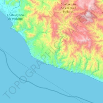
Название: Топографическая карта Aquila, высота, рельеф.
Местонахождение: Aquila, Michoacán, Mexico (18.08332 -103.71189 18.68546 -102.73777)
Средняя высота: 519 м
Минимальная высота: 0 м
Максимальная высота: 2 849 м
Сделать пожертвование
Другие топографические карты
Нажмите на карту, чтобы просмотреть ее топографию, ее высоту и ее рельеф.
Morelia
Under the Köppen climate classification, Morelia has a subtropical highland climate (abbreviated Cwb on climate maps), with warm-to-hot days and cool nights year round due to its high elevation. Most precipitation falls during the summer monsoon season from June to September. Average monthly temperatures are…
Средняя высота: 2 071 м
Сделать пожертвование
Сделать пожертвование
Сделать пожертвование
Zamora
The city of Zamora is an important economic center in the state and the most significant population center between the cities of Morelia and Guadalajara. The city is located on the Tarascan Plateau in the northwestern part of the state, at an elevation of 1,567 m (5,141 ft) above sea level. Zamora is…
Средняя высота: 1 798 м
Сделать пожертвование
Morelia
Under the Köppen climate classification, Morelia has a subtropical highland climate (abbreviated Cwb on climate maps), with warm-to-hot days and cool nights year round due to its high elevation. Most precipitation falls during the summer monsoon season from June to September. Average monthly temperatures are…
Средняя высота: 2 071 м
Zitácuaro
Mexico > Michoacán > Zitácuaro
Zitácuaro stands at 19°26′N 100°22′W / 19.433°N 100.367°W / 19.433; -100.367, in the northeast corner of Michoacán, some 150 km east of state capital Morelia, at an elevation of 1,942 metres above sea level. The municipality covers a total of 498 km2 and is drained by the Río Zitácuaro,…
Средняя высота: 2 157 м
Сделать пожертвование
Сделать пожертвование
Сделать пожертвование
Сделать пожертвование
Zamora
The city of Zamora is an important economic center in the state and the most significant population center between the cities of Morelia and Guadalajara. The city is located on the Tarascan Plateau in the northwestern part of the state, at an elevation of 1,567 m (5,141 ft) above sea level. Zamora is…
Средняя высота: 1 798 м
Сделать пожертвование