
Сделать пожертвование
Топографическая карта Winchester
Нажмите на карту, чтобы отобразить высоту.
Сделать пожертвование
Об этой карте
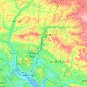
Название: Топографическая карта Winchester, высота, рельеф.
Местонахождение: Winchester, Hampshire, England, United Kingdom (50.85512 -1.45651 51.19700 -1.03391)
Средняя высота: 73 м
Минимальная высота: -3 м
Максимальная высота: 230 м
Сделать пожертвование
Другие топографические карты
Нажмите на карту, чтобы просмотреть ее топографию, ее высоту и ее рельеф.
Portsmouth
United Kingdom > England > Hampshire > Portsmouth
By road, Portsmouth lies 73.5 miles (118.3 km) from Central London, 49.5 miles (79.7 km) west of Brighton, and 22.3 miles (35.9 km) east of Southampton. Portsmouth is situated primarily on Portsea Island and is the United Kingdom's only island city, although parts of it have expanded onto the mainland. Gosport…
Средняя высота: 28 м
Сделать пожертвование
Headbourne Worthy
United Kingdom > England > Hampshire > Winchester > Kings Worthy
Средняя высота: 66 м
Сделать пожертвование
Winterhill Plantation
United Kingdom > England > Hampshire > Basingstoke and Deane > Whitchurch > Wells-In-The-Field
Средняя высота: 100 м
Сделать пожертвование
Basingstoke
United Kingdom > England > Hampshire > Basingstoke and Deane
Situated in a valley through the Hampshire Downs at an average elevation of 88 metres (289 ft) Basingstoke is a major interchange between Reading, Newbury, Andover, Winchester, and Alton, and lies on the natural trade route between the southwest of England and London. The area had been something of an…
Средняя высота: 109 м
Сделать пожертвование
Farnborough
United Kingdom > England > Hampshire > Rushmoor
Farnborough is located in the northeastern corner of the county of Hampshire, near the border with Surrey. The town occupies a valley setting, with the main urban area situated between the River Blackwater to the east and higher ground to the west. The topography gradually rises from the valley floor, reaching…
Средняя высота: 82 м
Liphook
United Kingdom > England > Hampshire > East Hampshire
In Samuel Lewis's 1831 Topographical Dictionary of England, he referred to Liphook as a hamlet in the parish of Bramshott.
Средняя высота: 121 м
Сделать пожертвование
Rowland's Copse, Red Hill
United Kingdom > England > Hampshire > East Hampshire > Rowlands Castle
Средняя высота: 42 м
Сделать пожертвование
Сделать пожертвование
Morgaston Wood
United Kingdom > England > Hampshire > Basingstoke and Deane > Sherborne St John
Средняя высота: 76 м
Сделать пожертвование
Сделать пожертвование
Сделать пожертвование
Bath Meadows
United Kingdom > England > Hampshire > Test Valley > Wellow > East Wellow
Средняя высота: 30 м
Сделать пожертвование
Сделать пожертвование
Hartley Mauditt
United Kingdom > England > Hampshire > East Hampshire > Hartley Mauditt
Средняя высота: 123 м
Сделать пожертвование
Сделать пожертвование
Basingstoke
United Kingdom > England > Hampshire > Basingstoke and Deane
Situated in a valley through the Hampshire Downs at an average elevation of 88 metres (289 ft) Basingstoke is a major interchange between Reading, Newbury, Andover, Winchester, and Alton, and lies on the natural trade route between the southwest of England and London. The area had been something of an…
Средняя высота: 107 м
Сделать пожертвование
Bitterne Grove
United Kingdom > England > Hampshire > Test Valley > Mottisfont > Dunbridge
Средняя высота: 39 м
Сделать пожертвование
Store House Gully
United Kingdom > England > Hampshire > Winchester > Fisher's Pond
Средняя высота: 45 м
Сделать пожертвование
Сделать пожертвование
Сделать пожертвование
Сделать пожертвование
Сделать пожертвование
Beacon Hill Nature Reserve
United Kingdom > England > Hampshire > Winchester > Exton
Средняя высота: 128 м
Сделать пожертвование
Сделать пожертвование
Bramshott Common
United Kingdom > England > Hampshire > East Hampshire > Bramshott
Средняя высота: 148 м
Сделать пожертвование
Сделать пожертвование