
Сделать пожертвование
Топографическая карта St. Thomas
Нажмите на карту, чтобы отобразить высоту.
Сделать пожертвование
Об этой карте
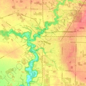
Название: Топографическая карта St. Thomas, высота, рельеф.
Местонахождение: St. Thomas, Southwestern Ontario, Ontario, Canada (42.74208 -81.24051 42.81294 -81.12042)
Средняя высота: 234 м
Минимальная высота: 189 м
Максимальная высота: 260 м
Сделать пожертвование
Другие топографические карты
Нажмите на карту, чтобы просмотреть ее топографию, ее высоту и ее рельеф.
Toronto
Despite its deep ravines, Toronto is not remarkably hilly, but its elevation does increase steadily away from the lake. Elevation differences range from 76.5 metres (251 ft) above sea level at the Lake Ontario shore to 209 m (686 ft) ASL near the York University grounds in the city's north end at the…
Средняя высота: 113 м
London
Canada > Ontario > London > London
London has a humid continental climate (Köppen Dfb), though due to its downwind location relative to Lake Huron and elevation changes across the city, it is virtually on the Dfa/Dfb (hot summer) boundary favouring the former climate zone to the southwest of the confluence of the South and North Thames Rivers,…
Средняя высота: 268 м
Сделать пожертвование
Peterborough
Canada > Ontario > Peterborough
Peterborough's topography is largely defined by land formations created by the receding Wisconsian glaciers 10,000–15,000 years ago. The South End and Downtown portions of the City sit on what was the bottom of the glacial Lake Peterborough—part of a glacial spillway created when glacial meltwaters from…
Средняя высота: 235 м
Сделать пожертвование
Tobermory
Canada > Ontario > Northern Bruce Peninsula > Tobermory
The deep waters at the mouth of Georgian Bay are home to Fathom Five, Canada's first National Marine Conservation Area. The park preserves a rich cultural legacy that includes 22 shipwrecks and several historic lighthouses. Fathom Five's freshwater ecosystem contains some of the most pristine waters of the…
Средняя высота: 182 м
Сделать пожертвование
Сделать пожертвование
Сделать пожертвование
Merrickville
Canada > Ontario > Leeds and Grenville Counties > Merrickville-Wolford
Средняя высота: 114 м
Сделать пожертвование
Guelph
This region of Ontario has cold winters and warm, humid summers, falling into the Köppen climate classification Dfb zone, with moderately high rainfall and snowfall. It is generally a couple of degrees cooler than lower elevation regions on the Great Lakes shorelines, especially so in winter, the exception…
Средняя высота: 344 м
Keswick
Canada > Ontario > York Region
Keswick's geographical coordinates are 44.22°N, 79.45°W, and its elevation above sea level is 221m/762 ft. It has a geographical area of 16.25 km² according to Statistics Canada. It is bound on the north by Roches Point, the east by Woodbine Avenue, the south by East Gwillimbury (Ravenshoe Road) and the…
Средняя высота: 228 м
Сделать пожертвование
Mount St. Patrick Mountains
Canada > Ontario > Renfrew County > Greater Madawaska
Средняя высота: 390 м
Сделать пожертвование
Pointe au Baril
Canada > Ontario > Parry Sound District > The Archipelago Township
Средняя высота: 177 м
Сделать пожертвование
Сделать пожертвование
Сделать пожертвование
Nolalu
Canada > Ontario > Thunder Bay District > Unorganized Thunder Bay District
Средняя высота: 370 м
Сделать пожертвование
Little Crosby Lake
Canada > Ontario > Leeds and Grenville Counties > Rideau Lakes
Средняя высота: 166 м
Сделать пожертвование
Queenston Heights Park
Canada > Ontario > Niagara Region > Niagara-on-the-Lake > Queenston
Средняя высота: 139 м
Сделать пожертвование
Сделать пожертвование
Сделать пожертвование
Сделать пожертвование
Сделать пожертвование
Сделать пожертвование
Сделать пожертвование
London
London has a humid continental climate (Köppen Dfb), though due to its downwind location relative to Lake Huron and elevation changes across the city, it is virtually on the Dfa/Dfb (hot summer) boundary favouring the former climate zone to the southwest of the confluence of the South and North Thames Rivers,…
Средняя высота: 269 м
Сделать пожертвование
Сделать пожертвование
Restoule
Canada > Ontario > Parry Sound District > Unorganized Centre Parry Sound
Средняя высота: 237 м
Сделать пожертвование
Сделать пожертвование
Sunbow Lake
Canada > Ontario > Thunder Bay District > Unorganized Thunder Bay District
Средняя высота: 491 м
Сделать пожертвование