
Сделать пожертвование
Топографическая карта Parry Sound
Нажмите на карту, чтобы отобразить высоту.
Сделать пожертвование
Об этой карте
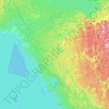
Название: Топографическая карта Parry Sound, высота, рельеф.
Местонахождение: Parry Sound, Ontario, Canada (45.02753 -80.74553 46.30753 -79.46553)
Средняя высота: 235 м
Минимальная высота: 172 м
Максимальная высота: 499 м
Сделать пожертвование
Другие топографические карты
Нажмите на карту, чтобы просмотреть ее топографию, ее высоту и ее рельеф.
Ottawa
Ottawa, the capital city of Canada, is situated on the south bank of the Ottawa River at the confluence with the Rideau River. The city's topography is characterized by gently rolling terrain with elevations ranging from approximately 44 meters (144 feet) above sea level at the Ottawa River to its highest…
Средняя высота: 105 м
Toronto
Despite its deep ravines, Toronto is not remarkably hilly, but its elevation does increase steadily away from the lake. Elevation differences range from 76.5 metres (251 ft) above sea level at the Lake Ontario shore to 209 m (686 ft) above sea level near the York University grounds in the city's north end at…
Средняя высота: 139 м
Сделать пожертвование
Toronto
Despite its deep ravines, Toronto is not remarkably hilly, but its elevation does increase steadily away from the lake. Elevation differences range from 76.5 metres (251 ft) above sea level at the Lake Ontario shore to 209 m (686 ft) ASL near the York University grounds in the city's north end at the…
Средняя высота: 139 м
Richmond Hill
Canada > Ontario > York Region
The village of Richmond Hill was incorporated by a bylaw of the York County Council on June 18, 1872, coming into effect January 1, 1873. In September 1956, the Ontario Municipal Board approved its elevation to Town status, effective January 1, 1957.
Средняя высота: 256 м
Сделать пожертвование
Eastern Ontario
Along the extreme western edge of Eastern Ontario is a continuation of the Laurentian Highlands, known as the Opeongo Hills, and they contain some of the highest elevations in Southern Ontario. They stretch into the northern portions of Central Ontario, near Algonquin Provincial Park.
Средняя высота: 243 м
Lake Scugog
Canada > Ontario > Durham Region > Kawartha Lakes
The stagnant waters of the lake caused a wave of deadly fevers in the surrounding farms, and the new lake limits quickly became very unpopular with the local residents. On one day in the summer of 1838, settlers from the countryside surrounding the lake rose up and using axes, flintlocks and pitchforks, tore…
Средняя высота: 269 м
Сделать пожертвование
Mississauga
Canada > Ontario > Peel Region
The shoreline of former Glacial Lake Iroquois roughly follows the Dundas Street alignment, although it is not noticeable in some places but is more prominent in others, such as the site of the former brickyard (Shoreline Dr. near Mavis Rd.), the ancient shoreline promenteau affords a clear view of downtown…
Средняя высота: 151 м
Lake Nipissing
Canada > Ontario > Nipissing District
Lake Nipissing (/ˈnɪpəsɪŋ/; French: lac Nipissing, Ojibwe: Gichi-nibiinsing-zaaga’igan) is a lake in the Canadian province of Ontario. It has a surface area of 873.3 km2 (337.2 sq mi), a mean elevation of 196 m (643 ft) above sea level, and is located between the Ottawa River and Georgian Bay. Lake…
Средняя высота: 272 м
Сделать пожертвование
Сделать пожертвование
Lake Ontario
Lake Ontario is the easternmost of the Great Lakes and the smallest in surface area (7,340 sq mi, 18,960 km2), although it exceeds Lake Erie in volume (393 cu mi, 1,639 km3). It is the 13th largest lake in the world. When its islands are included, the lake's shoreline is 712 miles (1,146 km) long. As the last…
Средняя высота: 214 м
Сделать пожертвование
Hamilton
Hamilton's climate is humid-continental, characterized by changeable weather patterns. In the Köppen classification, Hamilton it is on the Dfb/Dfa border found in southern Ontario because the average temperature in July is 22.0 °C (71.6 °F). However, its climate is moderate compared with most of Canada. The…
Средняя высота: 187 м
Deep River
Canada > Ontario > Renfrew County
John Bland, an architecture professor at McGill University, developed the town's first master plan in 1944. Bland located the town between the existing Highway 17 and the Ottawa River. He designed a system of streets which generally followed the contours of the area's topography. Residential neighborhoods…
Средняя высота: 169 м
Сделать пожертвование
Kitchener
Canada > Ontario > Region of Waterloo
Kitchener is located in Southwestern Ontario, in the Saint Lawrence Lowlands. This geological and climatic region has wet-climate soils and deciduous forests. Situated in the Grand River Valley, the area is generally above 300 m (1,000 ft) in elevation.
Средняя высота: 336 м
Lake Temiskaming
Canada > Ontario > Timiskaming District > Unorganized West Timiskaming
Средняя высота: 279 м
Сделать пожертвование
Simcoe County
The road network in Simcoe County is based on a grid pattern, with most roads running north–south or east–west. The topography of the land has permitted roads to be set in predominantly straight lines.
Средняя высота: 265 м
Сделать пожертвование
Arnprior
Canada > Ontario > Renfrew County
Arnprior is located on the Trans-Canada Highway system, where Highway 417 to the east becomes the two-lane Highway 17 to the west. The town is served by the Arnprior Airport, elevation 108 m (355 ft), and the nearby Arnprior Water Aerodrome, elevation 100 m (330 ft), for general aviation; although there is no…
Средняя высота: 93 м
Сделать пожертвование
Larder Lake
Canada > Ontario > Timiskaming District > Larder Lake Township > Larder Lake
Средняя высота: 302 м
Markham
Canada > Ontario > York Region
Markham's average altitude is at 200 m (660 ft) and in general consists of gently rolling hills. The city is intersected by two rivers; the Don River and Rouge River, as well as their tributaries. To the north is the Oak Ridges Moraine, which further elevates the elevation towards the north.
Средняя высота: 216 м
Сделать пожертвование
Сделать пожертвование
Сделать пожертвование
Сделать пожертвование
Сделать пожертвование
lac Seul
Canada > Ontario > Kenora District > Unorganized Kenora District
Lac Seul is a large, crescent shaped reservoir in Kenora District, northwestern Ontario, Canada. It is approximately 241 km (150 mi) long. It has a maximum (regulated) depth of 47.2 m, with a surface elevation of 357 m above sea level. Its level is raised in the summer and then drawn down in the winter months…
Средняя высота: 374 м
Сделать пожертвование
Сделать пожертвование
Wasaga Beach
Canada > Ontario > Simcoe County
The Town of Wasaga Beach covers an area of 61.13 square kilometres (23.60 sq mi) comprised predominantly of sand and loamy sand that exhibit excessive to good drainage and irregular to moderately sloping topography. The poor soil quality makes it difficult to sustain lush lawns in the town. The Canada Land…
Средняя высота: 190 м
Hamilton
The airport's open, rural location and higher altitude results in lower temperatures, generally windier conditions, and higher snowfall amounts than lower, built-up areas of the city. The highest temperature ever recorded in Hamilton was 41.1 °C (106 °F) on July 14, 1868. The coldest temperature ever…
Средняя высота: 187 м
Сделать пожертвование
Сделать пожертвование
Сделать пожертвование
Сделать пожертвование
Harris Lake
Canada > Ontario > Parry Sound District > Unorganized Centre Parry Sound
Средняя высота: 209 м
London
London has a humid continental climate (Köppen Dfb), though due to its downwind location relative to Lake Huron and elevation changes across the city, it is virtually on the Dfa/Dfb (hot summer) boundary favouring the former climate zone to the southwest of the confluence of the South and North Thames Rivers,…
Средняя высота: 263 м
Сделать пожертвование
Сделать пожертвование
Сделать пожертвование
Сделать пожертвование