
Сделать пожертвование
Топографическая карта Buxton
Нажмите на карту, чтобы отобразить высоту.
Сделать пожертвование
Об этой карте
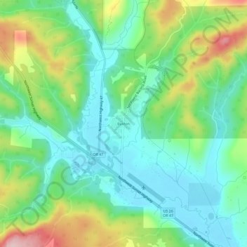
Название: Топографическая карта Buxton, высота, рельеф.
Местонахождение: Buxton, Washington County, Oregon, 97125, United States (45.66877 -123.21093 45.70877 -123.17093)
Средняя высота: 146 м
Минимальная высота: 69 м
Максимальная высота: 313 м
Сделать пожертвование
Другие топографические карты
Нажмите на карту, чтобы просмотреть ее топографию, ее высоту и ее рельеф.
Hillsboro
United States > Oregon > Washington County
Hillsboro is located at 45°31′N 122°59′W / 45.517°N 122.983°W / 45.517; -122.983 (Hillsboro, Oregon). The United States Census Bureau reports the city has a total area of 21.6 square miles (55.9 km2), all of which is land. In 2013, Hillsboro itself reported an area of 23.88 square miles…
Средняя высота: 53 м
Beaverton
United States > Oregon > Washington County
As of January 2020, Beaverton covers a total area of 19.7 square miles (51 km2), all of it land except for small creeks, ponds, and lakes. The city is located along the eastern edge of the Tualatin Valley just west of the Tualatin Mountains. It is bordered by Portland to the east, Hillsboro to the west, and…
Средняя высота: 106 м
Сделать пожертвование
Forest Glen Woods Natural Area
United States > Oregon > Washington County > Beaverton
Средняя высота: 75 м
Сделать пожертвование
Hillsboro
United States > Oregon > Washington County
The United States Census Bureau reports the city has a total area of 21.6 sq mi (55.9 km2), all of which is land. In 2013, Hillsboro itself reported an area of 23.88 sq mi (61.8 km2), equivalent to 15,283 acres (61.8 km2). The city is located in the Tualatin Valley, and the Tualatin River forms part of the…
Средняя высота: 53 м
Beaverton
United States > Oregon > Washington County
As of January 2020, Beaverton covers a total area of 19.7 square miles (51 km2), all of it land except for small creeks, ponds, and lakes. The city is located along the eastern edge of the Tualatin Valley just west of the Tualatin Mountains. It is bordered by Portland to the east, Hillsboro to the west, and…
Средняя высота: 106 м
Сделать пожертвование
Beaverton
United States > Oregon > Washington County
Beaverton covers a total area of 19.7 square miles (51 km2), all of it land except for small creeks, ponds, and lakes. The city is located along the eastern edge of the Tualatin Valley just west of the Tualatin Mountains. It is bordered by Portland to the east, Hillsboro to the west, and Tigard to the south.…
Средняя высота: 106 м
Hillsboro
United States > Oregon > Washington County
The United States Census Bureau reports the city has a total area of 21.6 sq mi (55.9 km2), all of which is land. In 2013, Hillsboro itself reported an area of 23.88 sq mi (61.8 km2), equivalent to 15,283 acres (61.8 km2). The city is located in the Tualatin Valley, and the Tualatin River forms part of the…
Средняя высота: 53 м
Beaverton
United States > Oregon > Washington County
Beaverton covers a total area of 19.7 square miles (51 km2), all of it land except for small creeks, ponds, and lakes. The city is located along the eastern edge of the Tualatin Valley just west of the Tualatin Mountains. It is bordered by Portland to the east, Hillsboro to the west, and Tigard to the south.…
Средняя высота: 106 м
Сделать пожертвование
Tualatin River
United States > Oregon > Washington County
The drainage area of the river is approximately 712 square miles (1,840 km2) with 27 creeks feeding into the Tualatin. Its watershed is 15 percent urbanized, 35 percent agricultural, and 50 percent forested. The river drops 1,800 feet (550 m) in elevation during its first 12 miles (19 km) and then only an…
Средняя высота: 117 м
Сделать пожертвование
Vern Galaway Memorial Park
United States > Oregon > Washington County > North Plains
Средняя высота: 56 м
Hillsboro
United States > Oregon > Washington County
Hillsboro is located at 45°31′N 122°59′W / 45.517°N 122.983°W / 45.517; -122.983 (Hillsboro, Oregon). The United States Census Bureau reports the city has a total area of 21.6 square miles (55.9 km2), all of which is land. In 2013, Hillsboro itself reported an area of 23.88 square miles…
Средняя высота: 53 м
Сделать пожертвование