
Топографическая карта Satyamangalam
Интерактивная карта
Нажмите на карту, чтобы отобразить высоту.
Satyamangalam
Sathyamangalam is situated on the southern side of the Western Ghats, which extend towards the east from the Nilgiri mountains. The general topography is not flat and covered by sloping lands. Bhavani river flows at the center of the town from west to east. Agricultural wet lands are predominant on both sides of the river and dry lands are predominant on the northern side of the town. The soil mainly consists of black loam, red loam and red sand.
Об этой карте
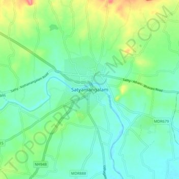
Название: Топографическая карта Satyamangalam, высота, рельеф.
Местонахождение: Satyamangalam, Sathyamangalam, Erode District, Tamil Nadu, 638401, India (11.46108 77.20514 11.54108 77.28514)
Средняя высота: 248 м
Минимальная высота: 224 м
Максимальная высота: 310 м
Другие топографические карты
Нажмите на карту, чтобы просмотреть ее топографию, ее высоту и ее рельеф.