
Сделать пожертвование
Топографическая карта Cheshunt
Нажмите на карту, чтобы отобразить высоту.
Сделать пожертвование
Об этой карте
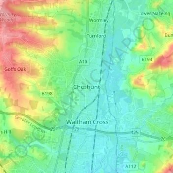
Название: Топографическая карта Cheshunt, высота, рельеф.
Местонахождение: Cheshunt, Broxbourne, Hertfordshire, England, EN8 9BW, United Kingdom (51.66205 -0.07359 51.74205 0.00641)
Средняя высота: 43 м
Минимальная высота: 14 м
Максимальная высота: 115 м
Сделать пожертвование
Другие топографические карты
Нажмите на карту, чтобы просмотреть ее топографию, ее высоту и ее рельеф.
Сделать пожертвование
Bishop's Stortford
United Kingdom > England > Hertfordshire > East Hertfordshire
Stortford, along with the rest of Britain, has a temperate maritime climate, with cool summers and mild winters. The nearest weather station for which averages and extremes are available is Stansted Airport, about .mw-parser-output .frac{white-space:nowrap}.mw-parser-output .frac .num,.mw-parser-output .frac…
Средняя высота: 83 м
St Albans
United Kingdom > England > Hertfordshire
St Albans was an ancient borough created following the dissolution of the monastery in 1539. It consisted of the ancient parish of St Albans (also known as the Abbey parish) and parts of St Michael and St Peter. The municipal corporation was reformed by the Municipal Corporations Act 1835 and the boundary was…
Средняя высота: 107 м
Сделать пожертвование