
Топографическая карта Mount Lucas
Интерактивная карта
Нажмите на карту, чтобы отобразить высоту.
Об этой карте
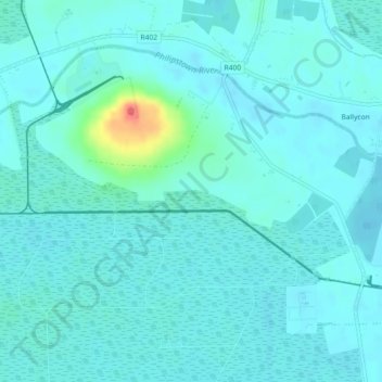
Название: Топографическая карта Mount Lucas, высота, рельеф.
Местонахождение: Mount Lucas, Esker ED, The Municipal District of Edenderry, County Offaly, Leinster, R35 XW10, Ireland (53.27824 -7.22510 53.29824 -7.20510)
Средняя высота: 76 м
Минимальная высота: 68 м
Максимальная высота: 121 м
Другие топографические карты
Нажмите на карту, чтобы просмотреть ее топографию, ее высоту и ее рельеф.
Burrow
Burrow, Kilcumeragh ED, The Municipal District of Tullamore, County Offaly, Leinster, Ireland
Средняя высота: 64 м
Hamilton's Lock
Hamilton's Lock, Lusmagh ED, The Municipal District of Birr, County Offaly, Leinster, Ireland
Средняя высота: 35 м
Ballintogher
Ballintogher, Rathfeston ED, The Municipal District of Edenderry, County Offaly, Leinster, Ireland
Средняя высота: 86 м
Coleraine
Coleraine, Silverbrook ED, The Municipal District of Tullamore, County Offaly, Leinster, Ireland
Средняя высота: 59 м
Edenderry
Edenderry, The Municipal District of Edenderry, County Offaly, Leinster, Ireland
Средняя высота: 74 м
The Municipal District of Birr
The Municipal District of Birr, County Offaly, Leinster, Ireland
Средняя высота: 97 м
The Municipal District of Edenderry
The Municipal District of Edenderry, County Offaly, Leinster, Ireland
Средняя высота: 80 м
Kinnity
Ireland > County Offaly > The Municipal District of Birr
Kinnity, The Municipal District of Birr, County Offaly, Leinster, Ireland
Средняя высота: 251 м
Tullamore
Tullamore, Tullamore Urban ED, The Municipal District of Tullamore, County Offaly, Leinster, R35 P761, Ireland
Средняя высота: 63 м
Carrig Bridge
Ireland > County Offaly > The Municipal District of Birr
Carrig Bridge, Seirkieran ED, The Municipal District of Birr, County Offaly, Leinster, R42 W542, Ireland
Средняя высота: 84 м
Shinrone
Ireland > County Offaly > The Municipal District of Birr > Shinrone
Shinrone, The Municipal District of Birr, County Offaly, Leinster, Ireland
Средняя высота: 72 м
Road
Road, Ballyburly ED, The Municipal District of Edenderry, County Offaly, Leinster, Ireland
Средняя высота: 87 м
Banagher
Ireland > County Offaly > Banagher
Banagher, The Municipal District of Birr, County Offaly, Leinster, R42 DE61, Ireland
Средняя высота: 43 м
Daingean
Ireland > County Offaly > Daingean
Daingean, The Municipal District of Edenderry, County Offaly, Leinster, Ireland
Средняя высота: 82 м
Down
Down, Clonygowan ED, The Municipal District of Edenderry, County Offaly, Leinster, Ireland
Средняя высота: 88 м