
Спасибо за поддержку этого сайта ❤️
Сделать пожертвование
Сделать пожертвование
Топографическая карта Bratislava
Нажмите на карту, чтобы отобразить высоту.
Спасибо за поддержку этого сайта ❤️
Сделать пожертвование
Сделать пожертвование
Bratislava
The Carpathian mountain range begins in city territory with the Little Carpathians (Malé Karpaty). The Záhorie and Danubian lowlands stretch into Bratislava. The city's lowest point is at the Danube's surface at 126 metres (413 ft) above mean sea level, and the highest point is Devínska Kobyla at 514 metres (1,686 ft). The average altitude is 140 metres (460 ft).
Спасибо за поддержку этого сайта ❤️
Сделать пожертвование
Сделать пожертвование
Об этой карте
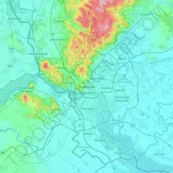
Название: Топографическая карта Bratislava, высота, рельеф.
Местонахождение: Bratislava, Old Town, District of Bratislava I, Region of Bratislava, Bratislava, 815 18, Slovakia (47.98351 16.94828 48.30351 17.26828)
Средняя высота: 175 м
Минимальная высота: 115 м
Максимальная высота: 611 м
Спасибо за поддержку этого сайта ❤️
Сделать пожертвование
Сделать пожертвование