
Топографическая карта Navi Mumbai
Интерактивная карта
Нажмите на карту, чтобы отобразить высоту.
Navi Mumbai
Navi Mumbai (Marathi pronunciation: [nəʋiː mumbəiː]), is a planned city situated on the west coast of the Indian subcontinent, located in the Konkan division of Maharashtra state, on the mainland of India. Navi Mumbai is part of the Mumbai Metropolitan Region (MMR). The city is divided into two, North Navi Mumbai and South Navi Mumbai, for the individual development of Panvel Mega City, which includes the area from Kharghar to Uran, including the Taloja node. The Agri and Koli Communities mainly reside in Navi Mumbai. Navi Mumbai was the host city for the inaugural final of the IPL (2008) at D.Y Patil Stadium. Thane Belapur Marg and Palm Beach Marg are major business attraction and upmarket residential areas respectively. Navi Mumbai has a population of 1,119,477 as per the 2011 provisional census. It has an average city elevation of 14 meters, excluding forest area.
Об этой карте
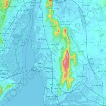
Название: Топографическая карта Navi Mumbai, высота, рельеф.
Местонахождение: Navi Mumbai, Thane Taluka, Thane, Maharashtra, India (18.99845 72.97786 19.18947 73.04970)
Средняя высота: 22 м
Минимальная высота: -3 м
Максимальная высота: 395 м
Другие топографические карты
Нажмите на карту, чтобы просмотреть ее топографию, ее высоту и ее рельеф.