Топографическая карта Moab
Интерактивная карта
Нажмите на карту, чтобы отобразить высоту.
Об этой карте
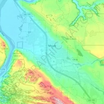
Название: Топографическая карта Moab, высота, рельеф.
Местонахождение: Moab, Grand County, Utah, 84532, United States (38.53621 -109.57965 38.60318 -109.51532)
Средняя высота: 1 357 м
Минимальная высота: 1 200 м
Максимальная высота: 1 746 м
Moab is just south of the Colorado River, at an elevation of 4,025 feet (1,227 m) on the Colorado Plateau. It is 18 miles (29 km) west of the Utah/Colorado state line. Via U.S. Route 191, it is 31 miles (50 km) south of Interstate 70 at Crescent Junction, and it is 54 miles (87 km) north of Monticello. Via Utah State Route 128 it is 46 miles (74 km) southwest of Cisco. The entrance to Arches National Park is 4 miles (6 km) north of Moab on US 191. Hurrah Pass is located on the trail between Moab and Chicken Corners.
Другие топографические карты
Нажмите на карту, чтобы просмотреть ее топографию, ее высоту и ее рельеф.
Westwater
United States > Utah > Grand County
Westwater, Grand County, Utah, United States
Средняя высота: 1 349 м
Cisco
United States > Utah > Grand County
Cisco, Grand County, Utah, 84515, United States
Средняя высота: 1 334 м
Rectory
United States > Utah > Grand County
Rectory, Grand County, Utah, United States
Средняя высота: 1 527 м
Delicate Arch
United States > Utah > Grand County
Delicate Arch, Delicate Arch Trail, Grand County, Utah, United States
Средняя высота: 1 409 м
Arches National Park
United States > Utah > Grand County
Arches National Park, Grand County, Utah, United States
Средняя высота: 1 476 м
Thompson Springs
United States > Utah > Grand County
Thompson Springs, Grand County, Utah, 84540, United States
Средняя высота: 1 583 м
Colorado River
United States > Utah > Grand County > Moab
Colorado River, Moab, Grand County, Utah, United States
Средняя высота: 1 668 м
Castle Valley
United States > Utah > Grand County
Castle Valley, Grand County, Utah, United States
Средняя высота: 1 610 м
Cottonwood Point
United States > Utah > Grand County
Cottonwood Point, Grand County, Utah, United States
Средняя высота: 2 346 м
La Sal Mountains Viewpoint
United States > Utah > Grand County
La Sal Mountains Viewpoint, Main Park Road, Grand County, Utah, 84532-2134, United States
Средняя высота: 1 347 м