
Топографическая карта Reigate
Нажмите на карту, чтобы отобразить высоту.
Reigate
Reigate is in central Surrey, around 19 mi (30 km) south of central London and 9 mi (14 km) north of Gatwick Airport. The town is in the Vale of Holmesdale, below the North Downs escarpment. The average elevation in the centre is 80 m (260 ft) above ordnance datum (OD) and the area is drained by the Wallace Brook and its tributaries, which feed the River Mole.
Об этой карте
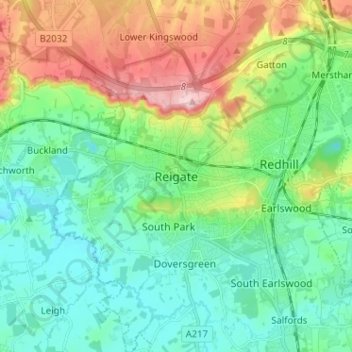
Название: Топографическая карта Reigate, высота, рельеф.
Местонахождение: Reigate, Reigate and Banstead, Surrey, England, RH2 0AA, United Kingdom (51.19766 -0.24571 51.27766 -0.16571)
Средняя высота: 100 м
Минимальная высота: 43 м
Максимальная высота: 236 м
Другие топографические карты
Нажмите на карту, чтобы просмотреть ее топографию, ее высоту и ее рельеф.
Lower Earlswood Lake
United Kingdom > England > Surrey > Reigate and Banstead > Redhill
Средняя высота: 75 м
Redhill Common
United Kingdom > England > Surrey > Reigate and Banstead > Redhill
Средняя высота: 92 м
Banstead Wood
United Kingdom > England > Surrey > Reigate and Banstead > Chipstead
Средняя высота: 145 м
Horley
United Kingdom > England > Surrey > Reigate and Banstead
Horley is at an altitude of around 54 m (177 ft) above mean sea level.
Средняя высота: 58 м