
Топографическая карта Les Coutures
Интерактивная карта
Нажмите на карту, чтобы отобразить высоту.
Об этой карте
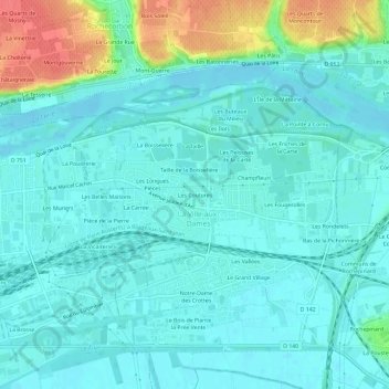
Название: Топографическая карта Les Coutures, высота, рельеф.
Местонахождение: Les Coutures, La Ville-aux-Dames, Tours, Indre-et-Loire, Centre-Val de Loire, France métropolitaine, 37700, France (47.37672 0.74786 47.41672 0.78786)
Средняя высота: 57 м
Минимальная высота: 44 м
Максимальная высота: 106 м
Другие топографические карты
Нажмите на карту, чтобы просмотреть ее топографию, ее высоту и ее рельеф.
La Grosse Chaintre
France > Centre-Val de Loire > Indre-et-Loire > La Ville-aux-Dames
La Grosse Chaintre, La Ville-aux-Dames, Arrondissement de Tours, Indre-et-Loire, Centre-Val de Loire, France métropolitaine, 37700, France
Средняя высота: 61 м
Le Grand Village
France > Centre-Val de Loire > Indre-et-Loire > La Ville-aux-Dames
Le Grand Village, La Ville-aux-Dames, Arrondissement de Tours, Indre-et-Loire, Centre-Val de Loire, France métropolitaine, 37700, France
Средняя высота: 51 м
Le Pré Change
France > Centre-Val de Loire > Indre-et-Loire > La Ville-aux-Dames
Le Pré Change, La Ville-aux-Dames, Tours, Indre-et-Loire, Centre-Val de Loire, France métropolitaine, 37700, France
Средняя высота: 61 м
Champfleuri
France > Centre-Val de Loire > Indre-et-Loire > La Ville-aux-Dames
Champfleuri, La Ville-aux-Dames, Tours, Indre-et-Loire, Centre-Val de Loire, France métropolitaine, 37700, France
Средняя высота: 59 м
Les Maisons Brûlées
France > Centre-Val de Loire > Indre-et-Loire > La Ville-aux-Dames > Les Maisons Brûlées
Les Maisons Brûlées, La Ville-aux-Dames, Tours, Indre-et-Loire, Centre-Val de Loire, France métropolitaine, 37700, France
Средняя высота: 51 м