
Сделать пожертвование
Топографическая карта Alice Springs
Нажмите на карту, чтобы отобразить высоту.
Сделать пожертвование
Alice Springs
Temperatures in Alice Springs vary widely, and rainfall can vary quite dramatically from year to year. In summer, the average maximum temperature is in the mid-30s, whereas in winter the average minimum temperature can be 5.5 °C (41.9 °F), with an average of 12.4 nights below freezing every year, providing frost. The elevation of the town is about 545 metres (1,788 feet), which contributes to the cool nights in winter. The highest temperature on record is 47.5 °C (117.5 °F) first recorded on 24 December 1891, whilst the record low is −7.5 °C (18.5 °F), recorded on 17 July 1976. This is also the lowest temperature recorded in the Northern Territory.
Сделать пожертвование
Об этой карте
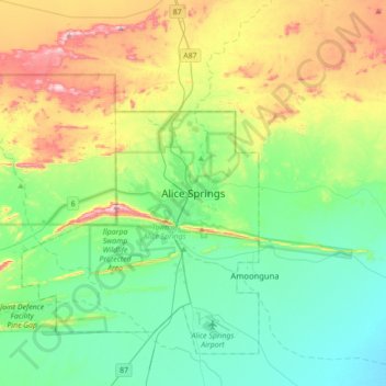
Название: Топографическая карта Alice Springs, высота, рельеф.
Местонахождение: Alice Springs, Town of Alice Springs, Northern Territory, 0870, Australia (-23.85839 133.72129 -23.53839 134.04129)
Средняя высота: 631 м
Минимальная высота: 505 м
Максимальная высота: 934 м
Сделать пожертвование