
Сделать пожертвование
Топографическая карта Stoke
Нажмите на карту, чтобы отобразить высоту.
Сделать пожертвование
Об этой карте
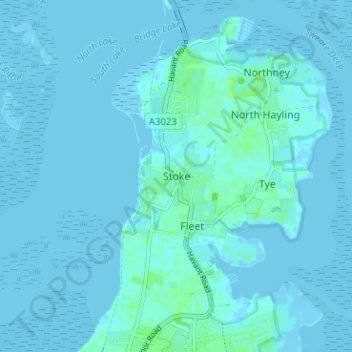
Название: Топографическая карта Stoke, высота, рельеф.
Местонахождение: Stoke, Havant, Hampshire, England, PO11 0LE, United Kingdom (50.79673 -0.99913 50.83673 -0.95913)
Средняя высота: 1 м
Минимальная высота: -3 м
Максимальная высота: 10 м
Сделать пожертвование
Другие топографические карты
Нажмите на карту, чтобы просмотреть ее топографию, ее высоту и ее рельеф.
Hayling Island
United Kingdom > England > Hampshire > Havant > North Hayling
An Iron Age shrine in the north of Hayling Island was later developed into a Roman temple in the 1st century BC and was first recorded in Richard Scott's Topographical and Historical Account of Hayling Island (1826). The site was dug between 1897 and 1907 and again from 1976 to 1978. The remains are now buried…
Средняя высота: 1 м
Hayling Island
United Kingdom > England > Hampshire > Havant > Fleet
An Iron Age shrine in the north of Hayling Island was later developed into a Roman temple in the 1st century BC and was first recorded in Richard Scott's Topographical and Historical Account of Hayling Island (1826). The site was dug between 1897 and 1907 and again from 1976 to 1978. The remains are now buried…
Средняя высота: 1 м
Сделать пожертвование