
Сделать пожертвование
Топографическая карта Edlibach
Нажмите на карту, чтобы отобразить высоту.
Сделать пожертвование
Об этой карте
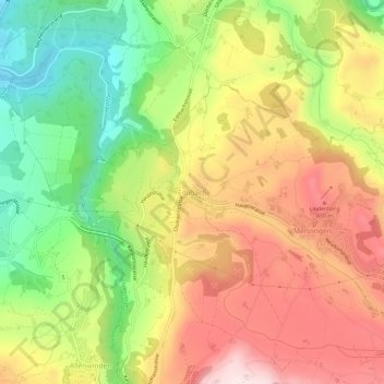
Название: Топографическая карта Edlibach, высота, рельеф.
Местонахождение: Edlibach, Menzingen, Zug, 6313, Switzerland (47.16227 8.55148 47.20227 8.59148)
Средняя высота: 693 м
Минимальная высота: 463 м
Максимальная высота: 921 м
Сделать пожертвование
Другие топографические карты
Нажмите на карту, чтобы просмотреть ее топографию, ее высоту и ее рельеф.
Menzingen
The municipality is located on a moraine plateau between the Lorze and Sihl rivers at an elevation of about 800 m (2,600 ft). In 1848 the municipality of Neuheim separated from Menzingen. It consists of the village of Menzingen and a number of hamlets and individual farm houses.
Средняя высота: 740 м
Oberägeri
The municipality is located in the eastern pre-alpine, high valley on the northern shores of the Ägerisee at an elevation of about 724 m (2,375 ft). It consists of the village of Oberägeri and the hamlets of Morgarten/Hauptsee and Alosen (at an elevation of 897 m (2,943 ft)) as well as scattered farm houses.
Средняя высота: 912 м
Сделать пожертвование