
Топографическая карта International Falls
Интерактивная карта
Нажмите на карту, чтобы отобразить высоту.
Об этой карте
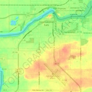
Название: Топографическая карта International Falls, высота, рельеф.
Местонахождение: International Falls, Koochiching County, Minnesota, United States of America (48.56193 -93.46523 48.60881 -93.36879)
Средняя высота: 347 м
Минимальная высота: 322 м
Максимальная высота: 368 м
Besides Fraser, there are still many towns that are smaller and annually overall colder than International Falls, many of these being mountain communities in the Rockies, as well as several in northern Minnesota. International Falls is still called the "Icebox of the Nation" after winning the claim against Fraser in court. One thing that does help or hinder International Falls is that Fraser is located within the Rocky Mountains, which would help to depress low temperatures while International Falls is located on relatively flat land, which takes longer to cool on warm summer nights. Also, while sub−freezing temperatures are very common at high elevation, valley sites in the Rockies during the winter, maximum temperatures that remain sub−freezing are quite rare, while at International Falls and much of the upper (Northern) Midwest they are of relatively frequent occurrence. This is reflected by the average monthly temperatures during the winter months.