
Сделать пожертвование
Топографическая карта Arlington
Нажмите на карту, чтобы отобразить высоту.
Сделать пожертвование
Arlington
The city lies on a glacial terrace formed during the Pleistocene epoch by the recession of the Cordilleran Ice Sheet. Arlington covers a series of hills that sit at an elevation of 100 to 200 feet (30 to 61 m) above sea level. Downtown Arlington is situated on a bluff above the confluence of the Stillaguamish River and its North and South Forks. Most of Arlington sits in the watersheds of the Stillaguamish River, Portage Creek, and Quilceda Creek. From various points in Arlington, the Olympic Mountains, Mount Pilchuck, and Mount Rainier are visible on the horizon.
Сделать пожертвование
Об этой карте
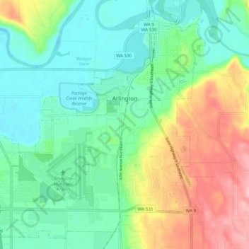
Название: Топографическая карта Arlington, высота, рельеф.
Местонахождение: Arlington, Snohomish County, Washington, 09223, United States (48.14479 -122.20401 48.20380 -122.10750)
Средняя высота: 60 м
Минимальная высота: 6 м
Максимальная высота: 172 м
Сделать пожертвование
Другие топографические карты
Нажмите на карту, чтобы просмотреть ее топографию, ее высоту и ее рельеф.
Glacier Peak
United States > Washington > Snohomish County
Despite its elevation of 10,541 feet (3,213 m), Glacier Peak is a small stratovolcano. Its relatively high summit is a consequence of its location atop a high ridge, but its volcanic portion extends only 1,600–3,200 feet (500–1,000 m) above the underlying ridge. Another Cascade Arc volcano with similar…
Средняя высота: 2 656 м
Сделать пожертвование
Сделать пожертвование
Bridal Veil Falls-Lower East Cascade
United States > Washington > Snohomish County
Средняя высота: 621 м
Сделать пожертвование
Glacier Peak
United States > Washington > Snohomish County
Despite its elevation of 10,541 feet (3,213 m), Glacier Peak is a small stratovolcano. Its relatively high summit is a consequence of its location atop a high ridge, but its volcanic portion extends only 1,600–3,200 feet (500–1,000 m) above the underlying ridge. Another Cascade Arc volcano with similar…
Средняя высота: 2 656 м
Сделать пожертвование
Whitehorse Mountain
United States > Washington > Snohomish County
Whitehorse Mountain is a peak near the western edge of the North Cascades in Washington state. It is located just southwest of the Sauk River Valley town of Darrington, near the northern boundary of Boulder River Wilderness in Mount Baker-Snoqualmie National Forest. While not of particularly high absolute…
Средняя высота: 1 430 м
Сделать пожертвование
Mill Creek
United States > Washington > Snohomish County > Mill Creek > Mill Creek
Средняя высота: 129 м
Сделать пожертвование