
Сделать пожертвование
Топографическая карта Prospect
Нажмите на карту, чтобы отобразить высоту.
Сделать пожертвование
Prospect
According to the Köppen classification, Prospect is Dfb, or a humid continental climate. The town has warm and humid summers with cold winters. Precipitation is spread throughout the year, with thunderstorms frequent during the summer months, and heavy snowfalls during the winter months. Due to Prospect's elevation and location, temperatures are often colder, leading to snow in the town while lower towns to its east have rain. Like Connecticut, Prospect frequently experiences Nor'easters and Blizzards during the winter, which can bring heavy snowfall to the town.
Сделать пожертвование
Об этой карте
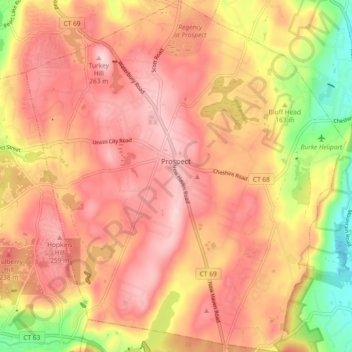
Название: Топографическая карта Prospect, высота, рельеф.
Местонахождение: Prospect, Naugatuck Valley Planning Region, Connecticut, 06712, United States (41.46474 -73.01817 41.53393 -72.93405)
Средняя высота: 193 м
Минимальная высота: 44 м
Максимальная высота: 279 м
Сделать пожертвование
Другие топографические карты
Нажмите на карту, чтобы просмотреть ее топографию, ее высоту и ее рельеф.
White Hills
United States > Connecticut > Naugatuck Valley Planning Region > Shelton
Средняя высота: 124 м
Mad River
United States > Connecticut > Naugatuck Valley Planning Region > Waterbury > Fair Lawn
Средняя высота: 134 м
Minortown
United States > Connecticut > Naugatuck Valley Planning Region > Woodbury
Средняя высота: 169 м
Bunker Hill
United States > Connecticut > Naugatuck Valley Planning Region > Waterbury
Средняя высота: 140 м
Сделать пожертвование
Bunker Hill
United States > Connecticut > Naugatuck Valley Planning Region > Waterbury
Средняя высота: 140 м
Traditions
United States > Connecticut > Naugatuck Valley Planning Region > Southbury > South Britain
Средняя высота: 112 м
Huntington
United States > Connecticut > Naugatuck Valley Planning Region > Shelton
Средняя высота: 111 м
Town Plot Hill
United States > Connecticut > Naugatuck Valley Planning Region > Waterbury
Средняя высота: 127 м
Сделать пожертвование
Millville
United States > Connecticut > Naugatuck Valley Planning Region > Naugatuck
Средняя высота: 132 м
Fox Hollow
United States > Connecticut > Naugatuck Valley Planning Region > Cheshire
Средняя высота: 64 м
Westview Heights
United States > Connecticut > Naugatuck Valley Planning Region > Middlebury
Средняя высота: 159 м
Union City
United States > Connecticut > Naugatuck Valley Planning Region > Naugatuck
Средняя высота: 124 м
Сделать пожертвование
Warsaw Park
United States > Connecticut > Naugatuck Valley Planning Region > Ansonia
Средняя высота: 107 м
Cedar Land
United States > Connecticut > Naugatuck Valley Planning Region > Southbury
Средняя высота: 103 м
Bunker Hill
United States > Connecticut > Naugatuck Valley Planning Region > Waterbury
Средняя высота: 140 м
Сделать пожертвование
Minortown
United States > Connecticut > Naugatuck Valley Planning Region > Woodbury
Средняя высота: 169 м
Gulls Hollow
United States > Connecticut > Naugatuck Valley Planning Region > Bethlehem
Средняя высота: 243 м
Allentown
United States > Connecticut > Naugatuck Valley Planning Region > Plymouth
Средняя высота: 244 м
Сделать пожертвование
Forestville
United States > Connecticut > Naugatuck Valley Planning Region > Bristol
Средняя высота: 99 м