
Сделать пожертвование
Топографическая карта Leicester
Нажмите на карту, чтобы отобразить высоту.
Сделать пожертвование
Об этой карте
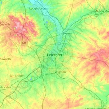
Название: Топографическая карта Leicester, высота, рельеф.
Местонахождение: Leicester, Leicestershire, England, LE1 5YA, United Kingdom (52.47620 -1.29320 52.79620 -0.97320)
Средняя высота: 109 м
Минимальная высота: 33 м
Максимальная высота: 269 м
Сделать пожертвование
Другие топографические карты
Нажмите на карту, чтобы просмотреть ее топографию, ее высоту и ее рельеф.
Leicestershire
United Kingdom > England > Leicestershire
A large part of the north-west of the county, around Coalville, forms part of the new National Forest area extending into Derbyshire and Staffordshire. The highest point of the county is Bardon Hill at 278 m (912 ft), which is also a Marilyn; with other hilly/upland areas of c. 150–200 metres (490–660 ft)…
Средняя высота: 98 м
Ashby-de-la-Zouch
United Kingdom > England > Leicestershire > North West Leicestershire
Средняя высота: 132 м
Сделать пожертвование