
Спасибо за поддержку этого сайта ❤️
Сделать пожертвование
Сделать пожертвование
Топографическая карта Guntur
Нажмите на карту, чтобы отобразить высоту.
Спасибо за поддержку этого сайта ❤️
Сделать пожертвование
Сделать пожертвование
Guntur
Guntur is located at 16°17′N 80°26′E / 16.29°N 80.43°E / 16.29; 80.43. It has an average elevation of 33 metres (108 ft) and is situated on the plains. There are few hills in the surrounding suburban areas and Perecherla Reserve Forest is located in the city's north-west. Guntur lies approximately 30 kilometres (19 mi) south of Amaravati, the capital of Andhra Pradesh.
Спасибо за поддержку этого сайта ❤️
Сделать пожертвование
Сделать пожертвование
Об этой карте
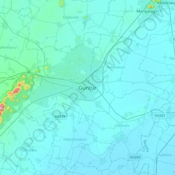
Название: Топографическая карта Guntur, высота, рельеф.
Местонахождение: Guntur, Andhra Pradesh, 522001, India (16.13152 80.29416 16.45152 80.61416)
Средняя высота: 29 м
Минимальная высота: 6 м
Максимальная высота: 474 м
Спасибо за поддержку этого сайта ❤️
Сделать пожертвование
Сделать пожертвование
Другие топографические карты
Нажмите на карту, чтобы просмотреть ее топографию, ее высоту и ее рельеф.