
Топографическая карта Stoke Row
Нажмите на карту, чтобы отобразить высоту.
Об этой карте
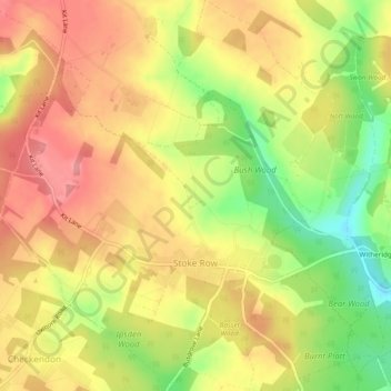
Название: Топографическая карта Stoke Row, высота, рельеф.
Местонахождение: Stoke Row, Checkendon, South Oxfordshire, Oxfordshire, England, United Kingdom (51.54156 -1.04443 51.57109 -0.99955)
Средняя высота: 164 м
Минимальная высота: 107 м
Максимальная высота: 204 м
Другие топографические карты
Нажмите на карту, чтобы просмотреть ее топографию, ее высоту и ее рельеф.
Harpsden Wood
United Kingdom > England > Oxfordshire > South Oxfordshire > Henley-on-Thames > Harpsden
Средняя высота: 63 м
Kingwood Common
United Kingdom > England > Oxfordshire > South Oxfordshire > Highmoor
Средняя высота: 125 м
Waterperry
United Kingdom > England > Oxfordshire > South Oxfordshire > Waterstock
Средняя высота: 63 м
Cane End
United Kingdom > England > Oxfordshire > South Oxfordshire > Gallowstree Common
Средняя высота: 108 м
Cowleaze Wood
United Kingdom > England > Oxfordshire > South Oxfordshire > Lewknor
Средняя высота: 209 м
Wittenham Clumps
United Kingdom > England > Oxfordshire > South Oxfordshire > Little Wittenham
Средняя высота: 65 м
Mongewell
United Kingdom > England > Oxfordshire > South Oxfordshire > Crowmarsh Gifford
Средняя высота: 59 м
Sonning Eye
United Kingdom > England > Oxfordshire > South Oxfordshire > Dunsden Green > Sonning Eye
Средняя высота: 44 м
Preston Crowmarsh
United Kingdom > England > Oxfordshire > South Oxfordshire > Benson
Средняя высота: 58 м
Ewelme Park
United Kingdom > England > Oxfordshire > South Oxfordshire > Swyncombe
Средняя высота: 172 м
Chalkhouse Green
United Kingdom > England > Oxfordshire > South Oxfordshire > Kidmore End
Средняя высота: 83 м
Wet n Wild Oxford
United Kingdom > England > Oxfordshire > South Oxfordshire > Berinsfield
Средняя высота: 51 м
Gatehampton
United Kingdom > England > Oxfordshire > South Oxfordshire > Goring-on-Thames
Средняя высота: 88 м
Baldon Row
United Kingdom > England > Oxfordshire > South Oxfordshire > Toot Baldon
Средняя высота: 73 м
Little Haseley
United Kingdom > England > Oxfordshire > South Oxfordshire > Great Haseley
Средняя высота: 73 м
Newnham Murren
United Kingdom > England > Oxfordshire > South Oxfordshire > Crowmarsh Gifford
Средняя высота: 59 м
Christmas Common
United Kingdom > England > Oxfordshire > South Oxfordshire > Watlington
Christmas Common is a hamlet in Watlington civil parish, Oxfordshire about 7+1⁄2 miles (12 km) south of Thame in Oxfordshire, close to the boundary with Buckinghamshire. The hamlet is 812 feet (247 m) above sea level on an escarpment of the Chiltern Hills. Because of its elevation, Christmas Common has two…
Средняя высота: 192 м
Chinnor Quarry 2B
United Kingdom > England > Oxfordshire > South Oxfordshire > Kingston Blount > Crowell
Средняя высота: 163 м
Kingston Stert
United Kingdom > England > Oxfordshire > South Oxfordshire > Aston Rowant
Средняя высота: 96 м
Woodperry
United Kingdom > England > Oxfordshire > South Oxfordshire > Stanton St John
Средняя высота: 89 м
Edmonds Park
United Kingdom > England > Oxfordshire > South Oxfordshire > Didcot > East Hagbourne
Средняя высота: 68 м
Overy
United Kingdom > England > Oxfordshire > South Oxfordshire > Dorchester-on-Thames
Средняя высота: 55 м
Witheridge Hill
United Kingdom > England > Oxfordshire > South Oxfordshire > Highmoor > Witheridge Hill
Средняя высота: 144 м
Path Hill
United Kingdom > England > Oxfordshire > South Oxfordshire > Whitchurch Hill
Средняя высота: 99 м
Brookhampton
United Kingdom > England > Oxfordshire > South Oxfordshire > Chiselhampton > Brookhampton
Средняя высота: 59 м
Burcot
United Kingdom > England > Oxfordshire > South Oxfordshire > Clifton Hampden
Средняя высота: 59 м
Peppard Common
United Kingdom > England > Oxfordshire > South Oxfordshire > Rotherfield Peppard
Средняя высота: 108 м