

Сделать пожертвование
Топографическая карта Stuttgart
Нажмите на карту, чтобы отобразить высоту.
Сделать пожертвование
Stuttgart
Stuttgart covers an area of 207.35 km2 (80 sq mi) and sits at elevation ranging from 207 m (679 ft) above sea level by the Neckar river to 549 m (1,801 ft) on Bernhartshöhe hill – something rather unique in large German cities. The most prominent elevated locales in Stuttgart are the Birkenkopf (511 m (1,677 ft)) on the edge of the Stuttgart basin, the Württemberg (411 m (1,348 ft)) rising above the Neckar valley, and the Grüner Heiner (395 m (1,296 ft)) at the northeast end of the city.
Сделать пожертвование
Об этой карте
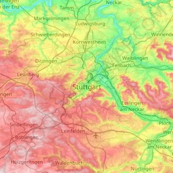
Название: Топографическая карта Stuttgart, высота, рельеф.
Местонахождение: Stuttgart, Regierungsbezirk Stuttgart, Baden-Württemberg, 70173, Germany (48.61845 9.02001 48.93845 9.34001)
Средняя высота: 353 м
Минимальная высота: 187 м
Максимальная высота: 549 м
Сделать пожертвование
Другие топографические карты
Нажмите на карту, чтобы просмотреть ее топографию, ее высоту и ее рельеф.

Сделать пожертвование


Сделать пожертвование

Сделать пожертвование
Zuffenhausen
Germany > Baden-Württemberg > Stuttgart
Zuffenhausen's terrain, a river valley carved into existence by the Feuerbach river, has two distinct elevations: Zuffenhausen with an average of 255 m (837 ft) and Zazenhausen at 252 m (827 ft). To the north and northwest are the vast stretches of the Langes Feld rolling hills on a height of over 300 m (980…
Средняя высота: 301 м